

GRAND RAPIDS, Mich. — On Tuesday, May 4 the latest update to NOAA's climate data determining what constitutes "average" temperature and precipitation conditions was released to the public.
This data represents a 30-year period from 1991 through 2020. The values for average conditions are updated once every 10 years, with the new set of values now representing average conditions used to compare against the daily, monthly and yearly observed weather.
RELATED: A new normal for hurricane season
Based on the new dataset West Michigan has seen some changes on both ends of the spectrum, with some areas seeing a rise in temperatures and others a drop. The same applied to precipitation in West Michigan.
Below you can see some of the data listed for Grand Rapids, Muskegon and Holland.
Grand Rapids:
- Average high now 58.2°, a rise of 0.3°.
- Average low now 40.5°, a rise of 0.3°.
- Average precipitation now 39.4", a rise of 1.13".
- Average snowfall now 77.6", a rise of 2.7".
- Days with 1"+ precip now 8.3, up from 7.7.
Muskegon:
- Average high now 57.9°, a rise of 1.5°.
- Average low now 40.9°, a rise of 0.4°.
- Average precipitation now 35.08", a rise of 1.59".
- Average snowfall now 87.2", a fall of 6.5".
- Days with 1"+ precip now 6.6, up from 5.5.
Holland:
- Average high now 57.9°, a fall of 0.5°.
- Average low now 40.6°, a fall of 1.2°.
- Average precipitation now 34.76", a fall of 1.7".
- Average snowfall not available.
- Days with 1"+ precip now 6.5, previously unknown.
Of the data shown here, Muskegon and Holland had more change in value for their normals when compared to the previous span for this data. This, in many ways, can be attributed to the variability of lake conditions in a given year, impacting the weather of the cities along the shoreline.
It will be worth monitoring lake conditions, especially ice levels in winter, to see if weather patterns hold to this new normal or continue to experience variability over the next decade.
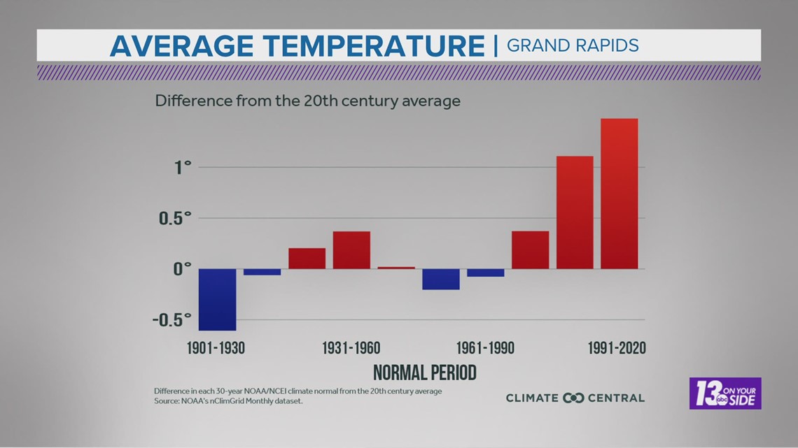
One trend looks to be a bit more steady though, and that would be increasing average temperatures for Grand Rapids. For the third straight climate normal period, Grand Rapids has seen a temperature rise. You can see that data in the graph below.

If you would like to look up more detailed information for average weather conditions in your city, more locations can be found here.
-- Meteorologist Michael Behrens
Follow me on social media! Facebook Meteorologist Michael Behrens, Twitter @MikeBehrensWX, and Instagram @MikeBehrensWX.
Email me at: MBehrens@13OnYourSide.com
Have a 30-second video or still photo to share? We'd love to share it with everyone! Email your image to Weather@13OnYourSide.com or post it to our 13OnYourSide Facebook Page.
►Make it easy to keep up to date with more stories like this. Download the 13 ON YOUR SIDE app now.
Have a news tip? Email news@13onyourside.com, visit our Facebook page or Twitter. Subscribe to our YouTube channel.