
GRAND RAPIDS, Mich. — Welcome back, Old Man Winter! Wednesday will kickstart a more typical winter pattern for late January, instead of the abnormally warm temperatures and lackluster snow as of late.
In a nutshell, a broader storm system will bring winter impacts on Wednesday across the Ohio River Valley into Metro Detroit, with West Michigan on the outskirts. While our neck of the woods will NOT contend with significant snow, there will be accumulation and minor travel impacts for the middle point of the week.
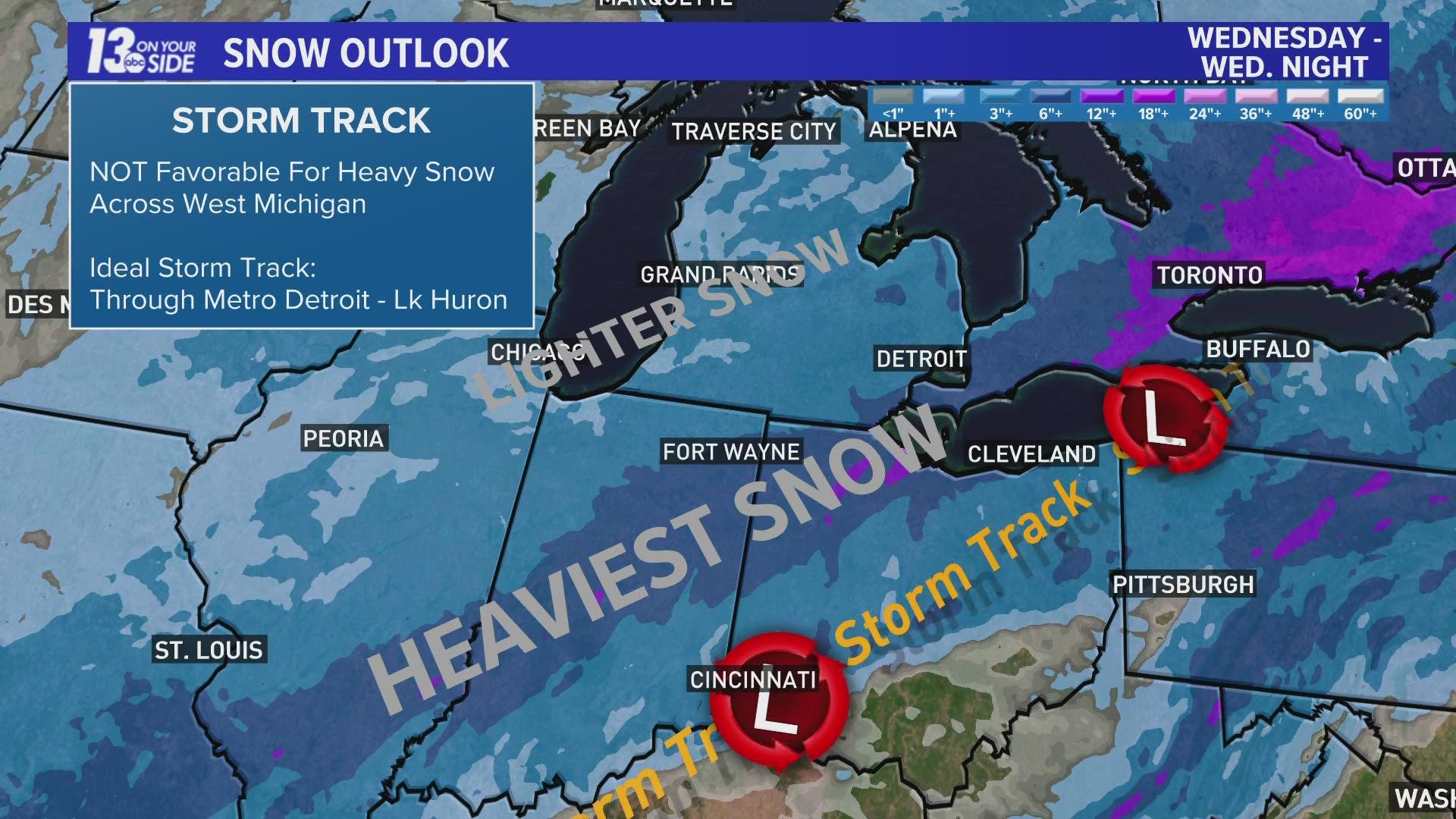
STORM TRACK & TIMING (WEDNESDAY)
Currently – as of Tuesday morning – low pressure is centered over Texas, with a trek toward the Ohio River Valley by the end of Tuesday night.
Here at home, snow will become widespread throughout the morning hours Wednesday. Impacts for the morning commute will vary, with slippery road conditions more likely southward of I-96. With road temperatures near freezing, snow will not take long to stick to untreated surfaces.
Snow is expected to be steady throughout the entirety of the daylight hours, with different degrees of intensity depending on location. The heaviest swaths of snow will be more common south and east of Grand Rapids, compared to lighter snow expected northward of I-96. Throughout Wednesday, the center of low pressure will be tracking across eastern Ohio.
Snow showers will taper off quickly Wednesday evening after sunset as the area of low pressure associated with this storm system presses well eastward into upstate New York/Ontario.
The overall track of this storm system (through eastern Ohio - Lake Erie - Lake Ontario - Upstate New York) is not favorable for impactful snow across West Michigan. Model data has been consistent with this track, along with the heaviest snow remaining displaced southeastward.

ACCUMULATION & IMPACTS
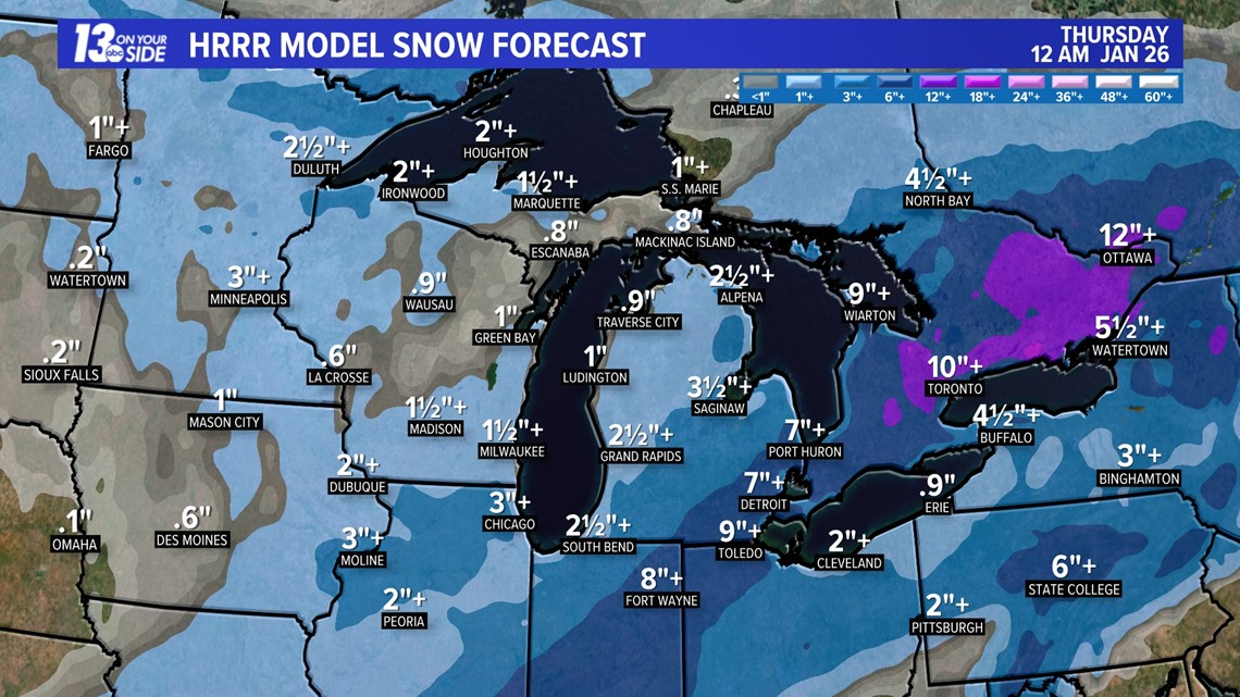
Broadly, accumulations will range between 1-4”+ across West Michigan. Specifically, the highest totals (3-4”+) will be south and east of Grand Rapids. This includes locations such as Ionia, Hastings and Kalamazoo. The lowest totals (1-2”) will be north of I-96, with 1” or less along US-10.

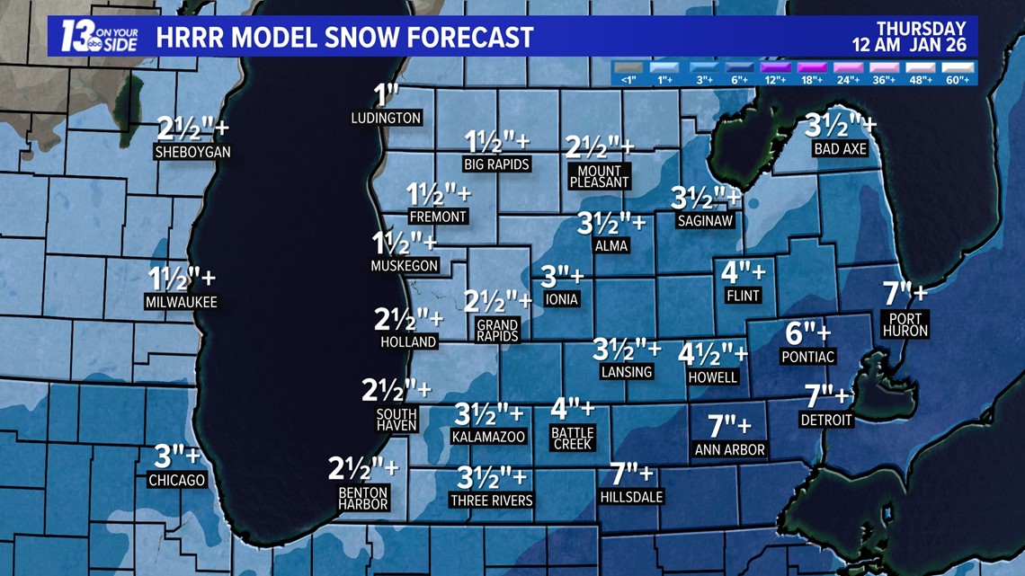
The heaviest snow of this entire storm system will fall across Indiana, Ohio, and Metro Detroit, where 6”+ is expected by the end of Wednesday.

It’s not significant snow for West Michigan standards, but it’ll be the most many locations have seen this entire month of January. Travel impacts will vary with lower-end snowfall, but untreated roads will become snow-covered and slick, especially south of I-96.
The snowfall will be a wetter and heavier type, which is a ‘greasier’ snow on roadways – harder for road crews to clean up. It’s also the type of snow that’s tougher to shovel, which is referred to as ‘heart-attack snow’.
Drifting snow is not expected to be a major impact, but wind gusts will approach the 20-30 mph range. This will cause wind chill values to be mostly in the 10s throughout Wednesday.
FURTHER AHEAD
The final week of January will be more representative of winter weather, with several chances of snow and temperatures falling below-average.
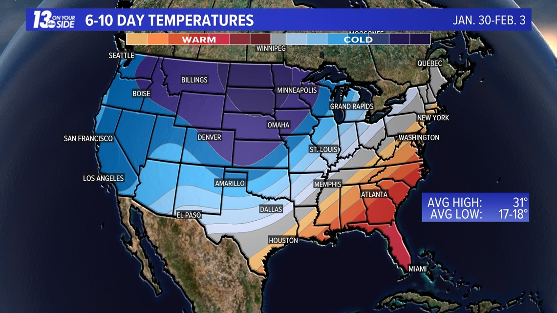
The next round of snowfall will arrive on Friday, in the way of a clipper system, with upwards of a few inches possible. Colder temperatures will settle in throughout the weekend – daytime highs in the 20s, nighttime lows in the 10s. This is represented in the 6-10 day outlook from the Climate Prediction Center, which gives West Michigan a higher probability of below-average temperatures. While details need to be ironed out, additional snow chances appear likely through early next week with the colder air around the Great Lakes.

Stick with 13 ON YOUR SIDE for the latest forecast!
Have a 30-second video or photo to share? We'd love to share it with everyone! Share your images by texting your name and location to 616.559.1310 or email to Weather@13OnYourSide.com or post it to our 13OnYourSide Facebook Page
►Make it easy to keep up to date with more stories like this. Download the 13 ON YOUR SIDE app now.
Have a news tip? Email news@13onyourside.com, visit our Facebook page or Twitter. Subscribe to our YouTube channel.