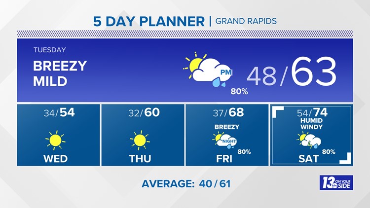
WZZM13 Forecast
Weather News
- New color-coded heat risk tool adds a level higher than red
- Lyrid meteor shower: When is the peak, where to look in the sky
- Storm Threat Increase | Strong winds, hail and an isolated tornado possible
- Fire weather warning issued for most of West Michigan
- Fire weather Tuesday, strong to severe storms Wednesday
10-Day Forecast
Tue
Apr 23
63
34
80%
11
MPH
WSW
Afternoon thunderstorms. Highs in the low 60s and lows in the upper 30s.
47%
Moderate
6:47 AM
8:34 PM
Wed
Apr 24
54
32
0%
11
MPH
WSW
Mix of sun and clouds. Highs in the mid 50s and lows in the low 30s.
55%
High
6:45 AM
8:36 PM
Thu
Apr 25
60
37
0%
13
MPH
SW
Partly cloudy. Highs in the low 60s and lows in the upper 30s.
59%
High
6:44 AM
8:37 PM
Fri
Apr 26
68
54
80%
13
MPH
ESE
Chance of afternoon showers. Highs in the upper 60s and lows in the mid 50s.
54%
Moderate
6:42 AM
8:38 PM
Sat
Apr 27
74
58
80%
13
MPH
E
Rain and wind with a few rumbles of thunder. Highs in the mid 70s and lows in the low 60s.
58%
Moderate
6:41 AM
8:39 PM
Sun
Apr 28
71
52
60%
14
MPH
SSE
Thunderstorms. Highs in the low 70s and lows in the low 60s.
64%
Moderate
6:39 AM
8:40 PM
Mon
Apr 29
68
50
60%
15
MPH
SW
Showers possible. Highs in the mid 60s and lows in the low 50s.
69%
High
6:38 AM
8:41 PM
Tue
Apr 30
65
48
0%
15
MPH
W
Partly cloudy. Highs in the low 60s and lows in the upper 40s.
60%
High
6:36 AM
8:42 PM
Wed
May 01
69
49
0%
14
MPH
W
Times of sun and clouds. Highs in the mid 60s and lows in the low 50s.
60%
High
6:35 AM
8:44 PM
Thu
May 02
70
49
40%
14
MPH
SSE
Times of sun and clouds. Highs in the upper 60s and lows in the upper 40s.
59%
High
6:34 AM
8:45 PM
Hourly Forecast
12 PM
Tue
59°
15%
19
MPH
SW
1 PM
Tue
60°
15%
18
MPH
SW
2 PM
Tue
61°
15%
18
MPH
SW
3 PM
Tue
61°
15%
16
MPH
SW
4 PM
Tue
61°
15%
15
MPH
SW
5 PM
Tue
61°
15%
17
MPH
SW
6 PM
Tue
60°
34%
17
MPH
SW
7 PM
Tue
58°
59%
16
MPH
SW
8 PM
Tue
55°
38%
14
MPH
SW
9 PM
Tue
53°
24%
12
MPH
WSW
10 PM
Tue
52°
15%
11
MPH
WSW
11 PM
Tue
50°
15%
9
MPH
WSW