
KALAMAZOO, Mich. — You've all seen the forecast...snow is coming to West Michigan. Specifically lake-effect-driven snowfall is expected in the days ahead.
While we all know the major cause for this snow, I mean it is in the name after all, do you know which factors favor a little lake-effect snow vs. school-closing mountains of the white stuff?
Dr. Lei Meng, an associate professor of geography, environment and tourism at Western Michigan University, wanted to break down the data and put together a list of key factors in a winter with lots of lake-effect snow, and one that doesn't quite meet expectations for the Lower Peninsula.
To do this he first needed to determine how much of our yearly snowfall is from a lake-effect-derived causation. From his research he found this number to be around 40%.
Next he needed to look at the trends and determine what factors influenced those outcomes.
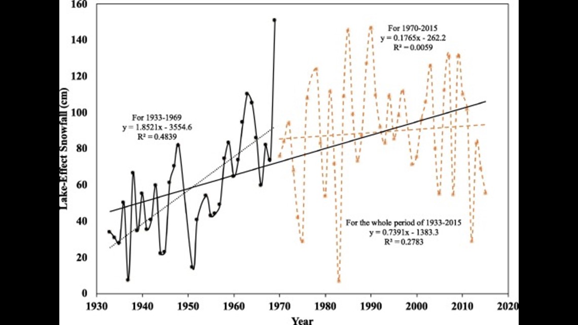
When looking at the data through the years he noticed that lake-effect snowfall was rising significantly from 1930 until around 1970. After that period the rise began to stabilize, but still trended slightly upward.

When it came to factors that led to years with high levels of lake-effect snowfall, there were several that stood out. These include air temperature, the El Niño Southern Oscillation (ENSO) and the maximum ice coverage on Lake Michigan.
The most significant of these factors is air temperature, with colder winters leading to higher levels of lake-effect snow. This snow mostly falls in the first part of the season, when the lake is still warm and unfrozen, and slows down as ice coverage builds.
The next major factor were the ENSO conditions. You may know this as whether we are in an El Niño pattern or a La Niña pattern. During years of La Niña conditions more lake-effect snow can be expected, with El Niño conditions leading to lower levels of lake-effect snowfall.
Finally, when it came to maximum ice coverage, years where Lake Michigan freezes to a larger extent will tend to have more lake-effect snowfall than years where the lake remains largely unfrozen. This may seem a bit counterintuitive, as the lake needs to be unfrozen to generate lake-effect snow, however, as stated above, air temperatures are the main driver of high lake-effect snowfall years.
If the lake remains largely unfrozen, this means the air temperatures have been warmer and thus less lake-effect snowfall will be likely. However, as a side note, years with less ice coverage on Lake Michigan can lead to lake-effect snow being generated deeper than usual into the winter season and early spring, though the yearly total of lake-effect snow will usually be lower in totality.
RELATED: What is lake-effect snow?
As for this year, Dr. Meng thinks we could be heading toward a season with higher levels of lake-effect snowfall since we are looking at the potential for a La Niña winter. However, the ultimate factor will be in whether or not we can get the cold air needed to kick the lake-effect machine into high gear.
Either way it goes, the 13 On Your Side Weather Team will be here to track the storms and keep you informed all winter long!
-- Meteorologist Michael Behrens
Follow me on social media! Facebook Meteorologist Michael Behrens, Twitter @MikeBehrensWX, and Instagram @MikeBehrensWX.
Email me at: MBehrens@13OnYourSide.com
**More information about the research in this article can be found by CLICKING HERE.**
Have a 30-second video or still photo to share? We'd love to share it with everyone! Email your image to Weather@13OnYourSide.com or post it to our 13OnYourSide Facebook Page.
►Make it easy to keep up to date with more stories like this. Download the 13 ON YOUR SIDE app now.
Have a news tip? Email news@13onyourside.com, visit our Facebook page or Twitter. Subscribe to our YouTube channel.