MICHIGAN, USA — Periods of tranquility and times of storminess – the Memorial Day weekend in a nutshell. If your holiday plans revolve around the weather, it’s best to stay updated for any adjustments to the times of storminess.
FRIDAY
Much of Friday will be warm and quiet, with temperatures climbing into the lower/middle 80s – roughly 10°F above average for late May. With an offshore wind – south to southeast – the warmest spots will likely be closer to the lakeshore.
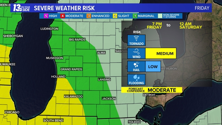
Focus turns to a swath of thunderstorms that’ll continue along a trailing cold front as it sweeps into West Michigan Friday evening. The timing of thunderstorms is slated to reach the lakeshore near or slightly after 7 p.m. and progress inland the rest of the evening, before exiting the area after midnight.
These thunderstorms come with a severe risk, with a Marginal Risk (level 1/5) for the bulk of the region. A Slight Risk (level 2/5) is currently in place for Allegan County, Van Buren County and a chunk of Kalamazoo County. Gusty to damaging wind is the main risk in place, with a lesser threat for hail. As of now, a tornado risk is not expected.


A caveat to the severe risk will be diminishing instability as thunderstorms arrive near or slightly after sunset. Unlike this past Tuesday, thunderstorms should not fizzle out completely before reaching West Michigan. With waning instability, however, the lakeshore has a greater opportunity for stronger thunderstorms, with a lessening threat inland.
MEMORIAL DAY WEEKEND

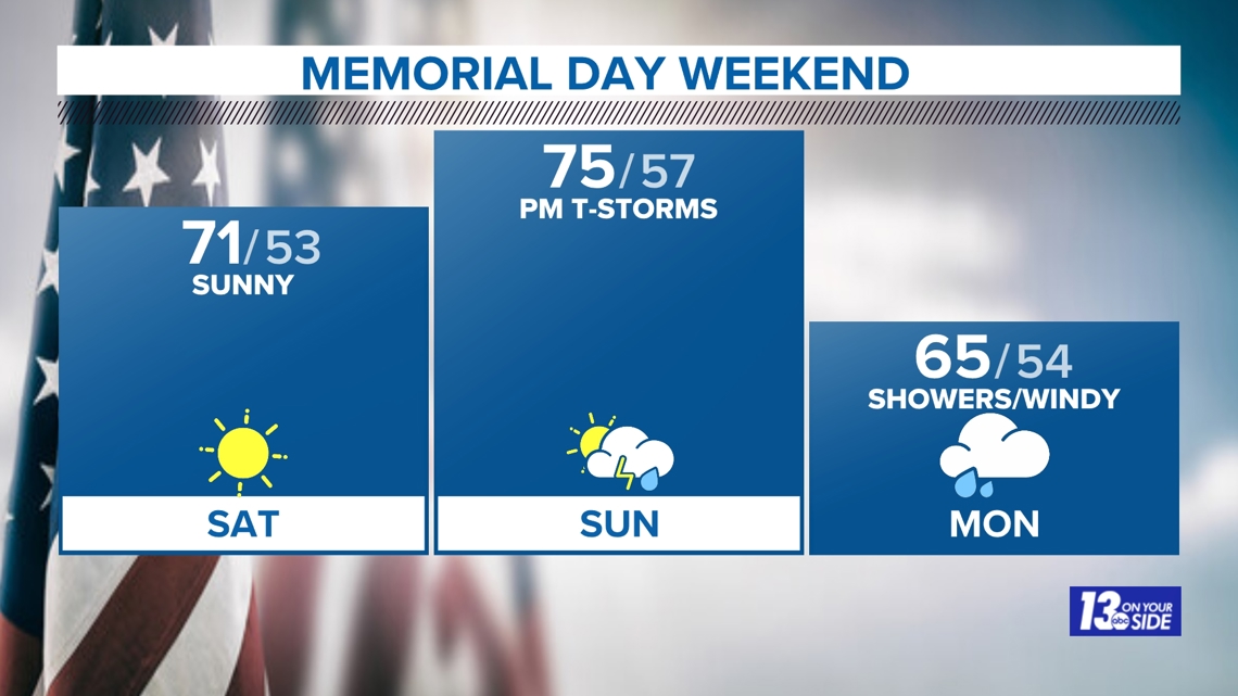
Saturday will be pleasant with sunshine the rule of thumb as high pressure settles overhead. It’ll be cooler but seasonable, with temperatures reaching the lower 70s. Conditions across much of Michigan will be similar, which is good news for those heading up north.
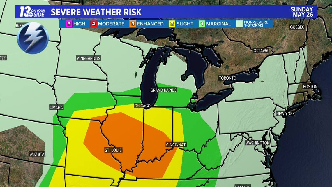
Active weather returns Sunday with another low pressure system heading toward the Great Lakes region. Thunderstorms are expected to arrive throughout the afternoon and evening, with a potential strong to severe weather risk. As of now, the highest severe weather risk remains southward of West Michigan, but bears watching as fine details are ironed out.

Memorial Day itself will be much cooler, windy and showery at times. No washout is expected but temperatures only reaching the 60s will be noticeable, especially with blustery conditions to reinforce the cooler temperatures.
BEACH & BOATING FORECAST
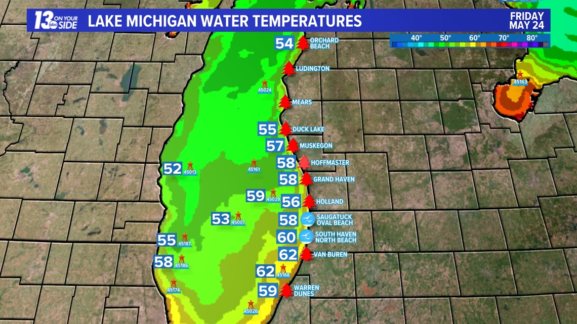
Memorial Day weekend is also known as the unofficial start to summer, with many returning to the water and/or beach. Lake Michigan water temperatures remain chilly — 50s to 60° — but much warmer than usual for late May due to the above-average winter and early spring temperatures. You can find the complete Beach & Boating forecast HERE.

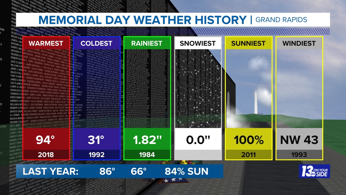
MEMORIAL DAY WEATHER HISTORY

Have a 30-second video or photo to share? We'd love to share it with everyone! Share your images by texting your name and location to 616.559.1310 or email to Weather@13OnYourSide.com or post it to our 13OnYourSide Facebook Page
►Make it easy to keep up to date with more stories like this. Download the 13 ON YOUR SIDE app now.
Have a news tip? Email news@13onyourside.com, visit our Facebook page or Twitter. Subscribe to our YouTube channel.
Watch 13 ON YOUR SIDE for free on Roku, Amazon Fire TV Stick, and on your phone.