
GRAND RAPIDS, Mich. —
HOW MUCH SNOW DID YOU GET?
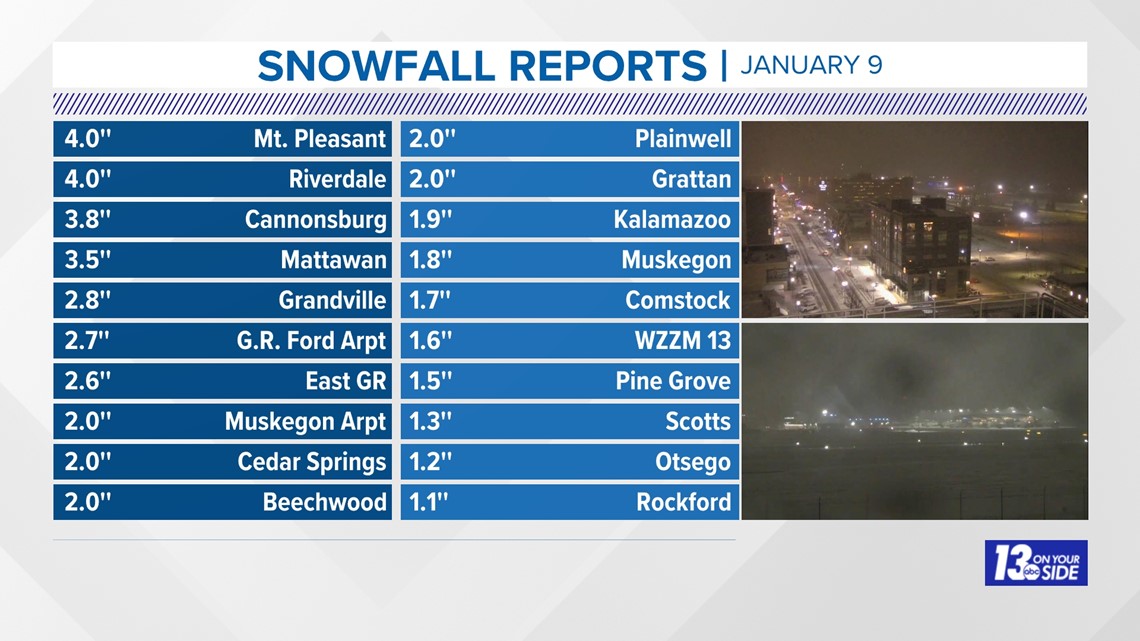
The first widespread snowfall of the season finally appeared Tuesday, January 9, 2024 spreading a slippery, slushy mess that impacted travel throughout the day. Reports of 1-4'' were common, as reported to the National Weather Service in Grand Rapids. Many of the reports are taken by citizen scientists at 7 am, long before the bulk of the snow arrived. The snow continued throughout the morning into the afternoon, changing briefly to rain generally SE of a line from Benton Harbor to Saginaw. This snowfall was unusually wet and heavy: snowfall ratios, i.e. the amount of water in the snow compared to the amount of snow is usually 10:1, meaning 10" of snow would equal 1" of water. In this case, it was closer to 5:1 where 5" of snow equals 1" of water.

HOW TO REPORT YOUR SNOWFALL AMOUNTS AND PHOTOS
You can submit your snowfall reports to us by texting the word STORM to 616.559.1310. Include your first and last name, your location, and what's in the photo for proper credit. We love horizontal (for TV) photos and videos of the falling snow, along with a ruler or yardstick for measurements.


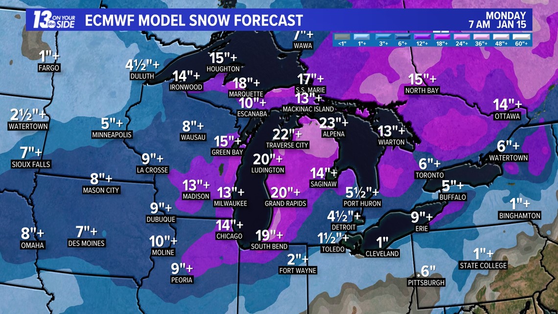
MORE SNOWSTORMS HEADING OUR WAY
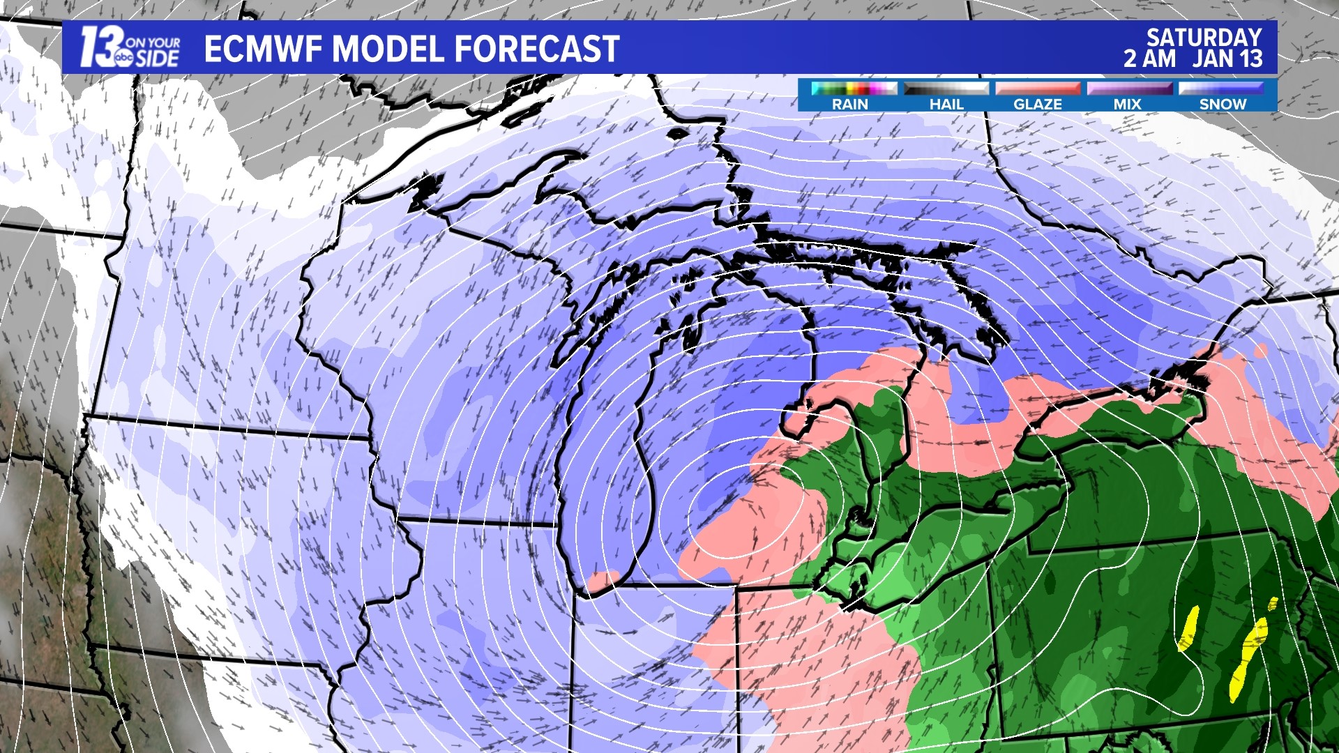
The Euro model forecast was spot-on with Tuesday's snowstorm with virtually no variation in its forecast track starting last Thursday, January 4. The latest Euro model run is forecasting several more rounds of snow with the greatest impact from Friday afternoon through Saturday.
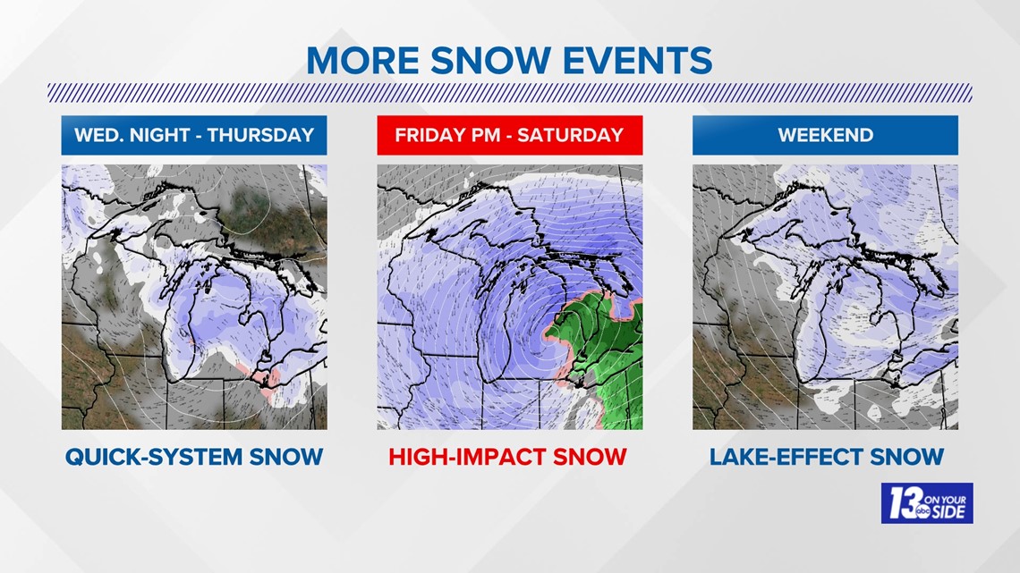
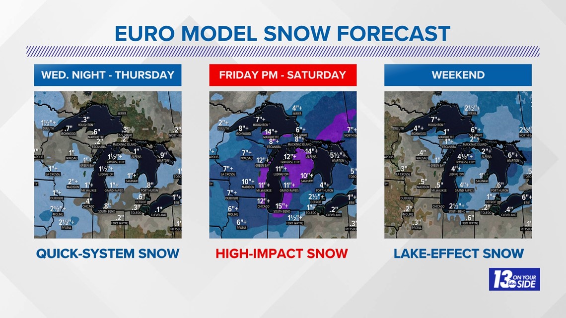
MORE SNOW EVENTS
- Wednesday Night - Thursday: The first round of quick-system snow arrives Wednesday night, lasting through Thursday. This is forecast to produce 1-2''+ amounts.
- Friday Afternoon - Saturday: The second round will be a high-impact snow event with wind gusts to 40+ mph along with heavy, wet snow. This is forecast to produce potential snow amounts up to 12''.
- Weekend: The third, and prolonged round of snow will be lake-effect snow, producing up to an additional 4"+ from Sunday morning through Monday morning. More snow accumulation is forecast throughout the week.


STORM-TOTAL SNOWFALL
From January 10-17, 2024 snowfall totals could approach 20''+.

Continue to watch the 13 On Your Side team of meteorologists for the latest updates..
Chief Meteorologist George Lessens
George is a graduate of Penn State University working for 13 On Your Side for over 43 years. He is a Certified Broadcast Meteorologist (CBM), a thirteen-time MAB® Weathercast Award Winner, two-time EMMY® Award Winner, NATAS® Silver Circle Award Winner, and Weather-Ready Nation® Ambassador.
Contact me at: GeorgeLessens@13OnYourSide.com
Follow me on X/Twitter @glessens and Facebook GeorgeLessensWZZM
Have a 30-second video or photo to share? We'd love to share it with everyone! Share your images by texting your name and location to 616.559.1310 or email to Weather@13OnYourSide.com or post it to our 13OnYourSide Facebook Page
►Make it easy to keep up to date with more stories like this. Download the 13 ON YOUR SIDE app now.
Have a news tip? Email news@13onyourside.com, visit our Facebook page or Twitter. Subscribe to our YouTube channel.
Watch 13 ON YOUR SIDE for free on Roku, Amazon Fire TV Stick, Apple TV and on your phone.