

GRAND RAPIDS, Mich. — It's winter.
And in the forecast over the next 48 hours, West Michigan includes record-breaking warmth, severe weather, a potential flash freeze, and snowfall.
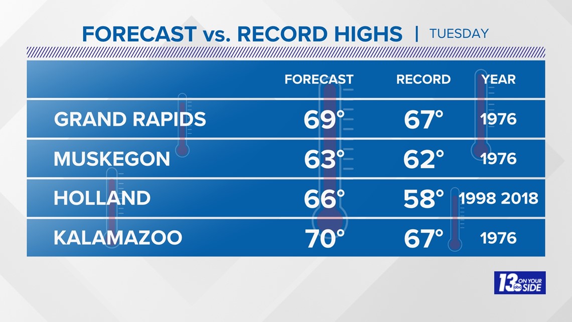
Grand Rapids has never recorded 70° in the month of February. That changed on Tuesday.
It's the first time Grand Rapids has reached 70° at any point in February and meteorological winter.
Muskegon, Holland and Battle Creek also set record highs for Feb. 27.
SPRING WARMTH TUESDAY
Impressive late February warmth will be prominent Tuesday, with temperatures soaring into the 60s to 70° by afternoon for most locations. Putting this in perspective, average high temperatures are in the upper 30s at this point of the year. Record high temperatures for Feb. 27 will likely be broken for all climate sites across West Michigan.
Grand Rapids has never recorded 70° in the month of February, with March 3 (1983) the earliest on record. The warmest February temperature for Grand Rapids was 69°, achieved on Feb. 11, 1999.

STORMS LATE TUESDAY
Thunderstorms are possible after 8 p.m. Tuesday through 3 a.m. Wednesday. The strongest chances for severe weather remain from I-96 and to the south from midnight to 2 a.m. With the timing of these storms being after sunset, there are some limiting factors. However, the storms still have the potential to produce strong damaging winds, large hail and even a spin-up tornado. Because of this, the Storm Prediction Center still has a majority of West Michigan under a level 2/5 risk for strong to severe storms.

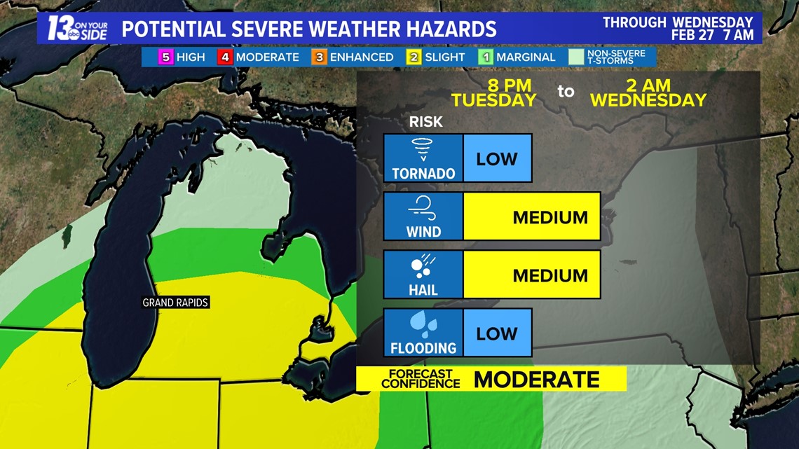
The main hazards of these storms remain strong gusty winds and large hail. A low-end threat for a tornado is possible, but limited.
You should have multiple ways to stay weather aware and receive critical weather information.
There are five direct ways in which you can receive weather alerts.
- NOAA Weather Radio. The first is NOAA Weather Radio. We often refer to them as the “smoke detector” for severe weather, because they will automatically sound an alarm in the case of a natural disaster or severe weather.
- Local Broadcast. There is also always your local TV station. The 13 ON YOUR SIDE Weather Department streams on-air and online during an active storm.
- Radio Station. Local radio stations should alert you if a storm is in your area. You can even set up devices like Alexa and Google Home to alert you with weather notifications.
- Smartphone. Your smartphones also offer numerous ways to receive critical weather alerts. We have a 13 ON YOUR SIDE Weather App that will allow you to track the storm and receive alerts.
- Outdoor Sirens. Outdoor sirens are also an option, as they will go off in the threat of immediate danger, but are only meant to be heard outdoors. So, if you are inside this should not be how you receive your severe weather alerts. Outdoor sirens can also be unreliable, difficult for those hard of hearing, and go off for other reasons beyond tornadoes.
WINTER FEEL WEDNESDAY
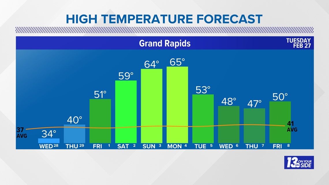
The strong cold front sweeps through West Michigan by daybreak Wednesday, plummeting temperatures into the 20s. This rapid drop, falling below freezing, brings the potential of a flash freeze throughout the morning. Icy conditions will be the major impact during the morning commute.
As temperatures fall, there’ll be a brief transition to snow showers accompanying the cold front’s passage. Snow accumulation is expected to be meager, with less than an inch expected. The colder temperatures will allow a lake effect component to the snow but is expected to taper off by afternoon.
Despite a return to winter conditions, another spring warm up is in sight by this upcoming weekend. High temperatures are expected to soar into the 50s by Friday and into the 60s by Sunday.

►Make it easy to keep up to date with more stories like this. Download the 13 ON YOUR SIDE app now.
Have a news tip? Email news@13onyourside.com, visit our Facebook page or Twitter. Subscribe to our YouTube channel.
Watch 13 ON YOUR SIDE for free on Roku, Amazon Fire TV Stick, Apple TV and on your phone.