
GRAND RAPIDS, Mich — Get ready, West Michigan! Another major snowstorm is heading our way.
WHAT
A low-pressure system is set to arrive by 8 a.m. on Friday, bringing continuous snowfall through Saturday early afternoon. This system is expected to unleash strong winds, heavy, dense snowfall, and an arctic blast of air, resulting in hazardous travel conditions, the potential for power outages and periods of very low visibility.
TIMING
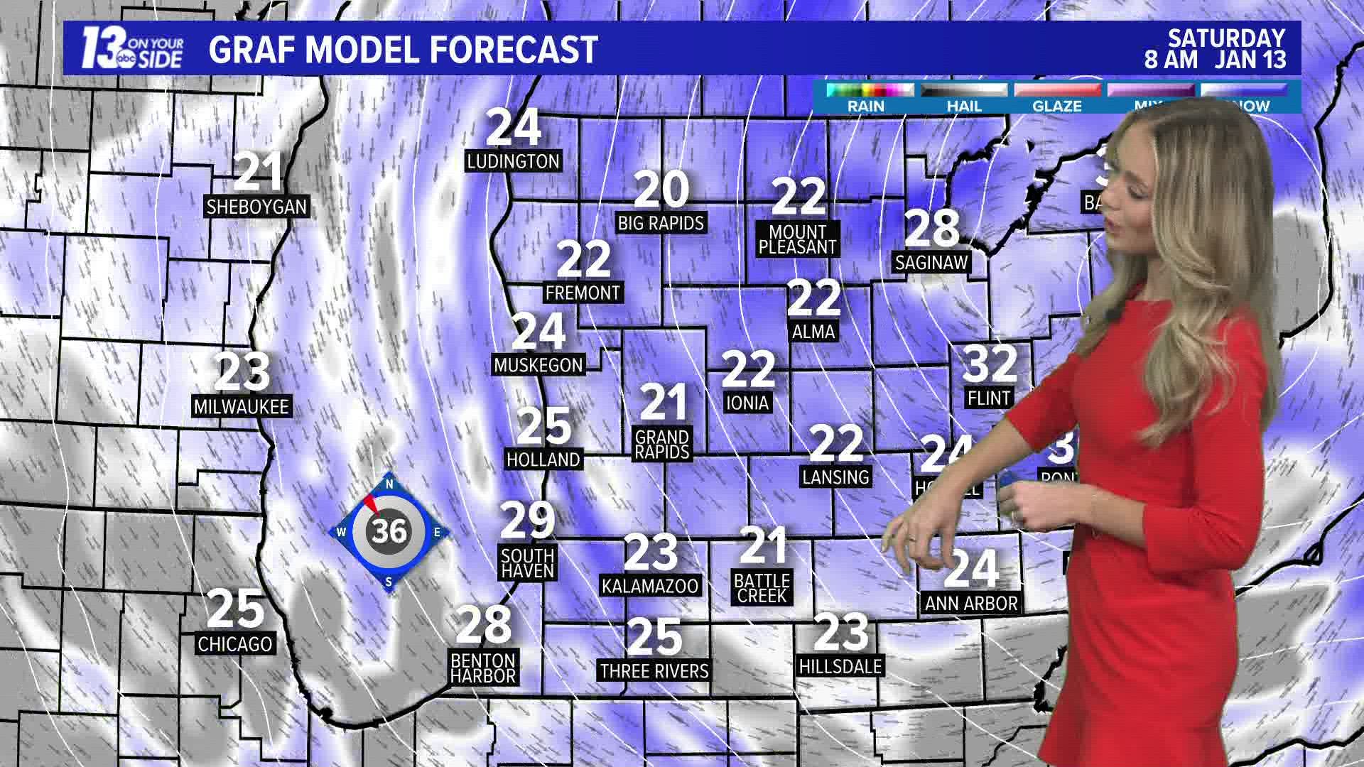
The snow will reach the lakeshore by 8 a.m. and move east/northeast throughout the morning. Snowfall rates are likely to peak during the late afternoon to early evening hours. This is also when we anticipate wind gusts of 35 to 45 mph, creating blizzard-like conditions during the evening commute.
There is a possibility of a brief period of rainfall after 9 p.m. in our southern counties. However, this will be short-lived and not cause any major changes to the forecast, as cold air filters in behind the system, causing temperatures to plummet overnight with additional snowfall. The low-pressure system is expected to depart West Michigan by noon on Saturday, with lake-effect snow kicking in behind it during Saturday afternoon.
TOTALS
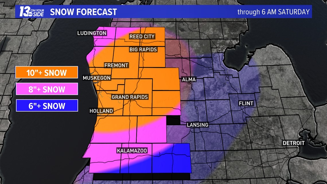
Between 9 a.m. Friday and 9 p.m. Friday, we will likely have 8"+ of heavy wet snow on the ground. We will have an additional 4"+ of snow overnight Friday and into Saturday morning. We anticipate an area receiving 12 inches, possibly even higher amounts, but we're not entirely confident about its specific location at this time. Adjustments for higher amounts are likely to be made Thursday evening and Friday morning.

IMPACTS
Traveling on the roadways is expected to be extremely difficult Friday night through Saturday morning. The combination of strong winds blowing snow and the heavy wet snow could create whiteout-like conditions throughout the evening commute. It could also cause tree branches to break and power outages.


After the system passes, frigid cold air works into West Michigan bringing out the coldest temperatures of the season. -10 to -20 wind chill values could result in frostbite in 30 minutes.
WARNINGS
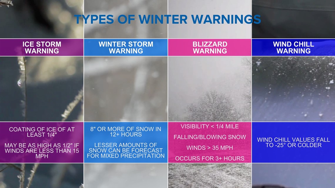
The National Weather Service is likely to issue a Winter Storm Warning for West Michigan Friday afternoon through Saturday morning. This warning signifies the expectation of 8 inches or more of snow within 12+ hours. There is the potential for certain areas to be upgraded to Blizzard Warnings, but as of now, it doesn't seem likely.

Have a 30-second video or photo to share? We'd love to share it with everyone! Share your images by texting your name and location to 616.559.1310 or email to Weather@13OnYourSide.com or post it to our 13OnYourSide Facebook Page
►Make it easy to keep up to date with more stories like this. Download the 13 ON YOUR SIDE app now.
Have a news tip? Email news@13onyourside.com, visit our Facebook page or Twitter. Subscribe to our YouTube channel.
Watch 13 ON YOUR SIDE for free on Roku, Amazon Fire TV Stick, and on your phone.