GRAND RAPIDS, Mich. — This morning's rain has exited the area and now we are set up for the potential of strong to severe storms. There will be several rounds of storms between 3 p.m. today and 3 p.m. tomorrow, some looking to have more strength than others.
Let's start with today's forecast.
Today (Tuesday, April 4)
The first timeframe for strong storms to possibly low-end severe storms is from 3 p.m. to 6:30 p.m., then again from midnight to 2 a.m. These storms will mainly be run-of-the-mill thunderstorms but could contain some severe elements. This includes damaging wind and large hail. Flooding will also remain a concern due to previous rainfall and heavy bursts of rain within thunderstorm cells.
Because of these concerns, the Storm Prediction Center (SPC) has placed us under a level 2 out of 5 threat for SW lakeshore communities and a level one out of five threat for the rest of the lower peninsula. Remember that level 5 is the highest and level 1 is the lowest.
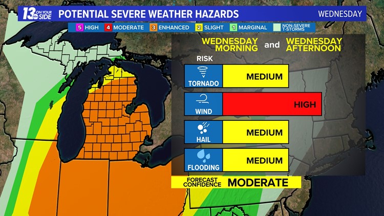
Tomorrow (Wednesday, April 5)
The threat of strong to severe storms increases Wednesday, especially from 11 a.m. to 3 p.m. This comes as the cold front interacts with our warm and unstable air left behind the warm front. As of now, it looks like these storms will be strongest east of US-131, but the SPC has placed the entire lower peninsula under a level three out of five threat for severe storms.
The main threats with this line of storms will be strong winds, hail and a few tornadoes. Flooding will still remain a concern due to previous rainfall and heavy bursts of rain within thunderstorms cells.
This portion of the forecast will likely fluctuate, so make sure to check back in over the next several hours.
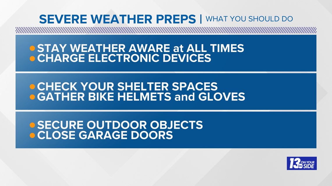
Here are some ways that you can remain weather aware and prepare for storms:

Have a 30-second video or photo to share? We'd love to share it with everyone! Share your images by texting your name and location to 616.559.1310 or email to Weather@13OnYourSide.com or post it to our 13OnYourSide Facebook Page


►Make it easy to keep up to date with more stories like this. Download the 13 ON YOUR SIDE app now.
Have a news tip? Email news@13onyourside.com, visit our Facebook page or Twitter. Subscribe to our YouTube channel.