
GRAND RAPIDS, Mich. — Wednesday officially marks the start of meteorological spring and the end of meteorological winter.
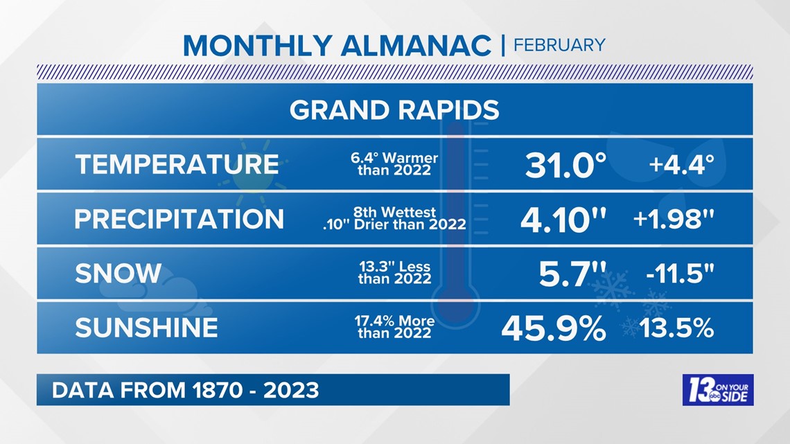
This winter was certainly unusual and the impacts of our latest climate trends were felt. We tied the season as the 7th warmest winter on record. Coming out with an average temperature of 31°. That's nearly 4° above average for the season.
Despite several nasty storms, we ended the season with slightly below-average snowfall totals but overall above-average precipitation. It seems as though we had at least one big storm each month of the season but less day-to-day snowfall.
While the season hadn't officially started in November, it definitely kicked us into it with 30 inches of lake effect in places like East Grand Rapids in a three-day stretch. This event ended up breaking our three-day snowfall record.
December kept the trend of memorable storms going with the 2022 Christmas Blizzard!
In my opinion, there are three main elements that make a winter storm nasty: 1. Widespread heavy snow 2. Strong winds 3. Arctic air. This system brought all three to a large portion of the country. Delaying travel and Christmas plans across the United States. It was impactful enough that our team put together an entire special on the coverage from the wild week.
January was off to a very quiet and mild start. It ended up being the 5th warmest January on record, the 5th cloudiest, and 9 inches below average seasonal snowfall. Despite seeing very little snow most of the month, we ended with another winter storm. It also came with the coldest morning of the season, waking up with temperatures reading at 3° and feeling subzero.


February kept the usual winter trend going with above-average temperatures by 4.4°, below-average snow, but above-average precipitation. In fact, we ended up breaking the daily rainfall record for Grand Rapids on February 27th.

While the month itself didn't bring much snow, it packed a punch at the end with two back-to-back ice storms. This brought the region our first ice storm warning since 2013 and knocked out power to large portions of SE West Michigan.
Totals were very impressive with multiple reports over a half inch. This coated trees, and cars, and brought down power across the region.

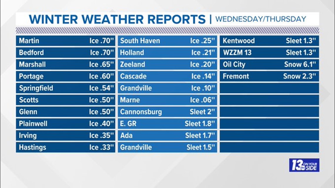
Just a few days later an additional ice storm hit and that knocked out power to an additional 70,000 + customers in our northern counties.
So, needless to say, this winter underperformed in terms of day-to-day snow and winter temperatures but over-performed in large winter storms. Now, we have technically entered into meteorological spring, but that does not mean we are done with big storms.
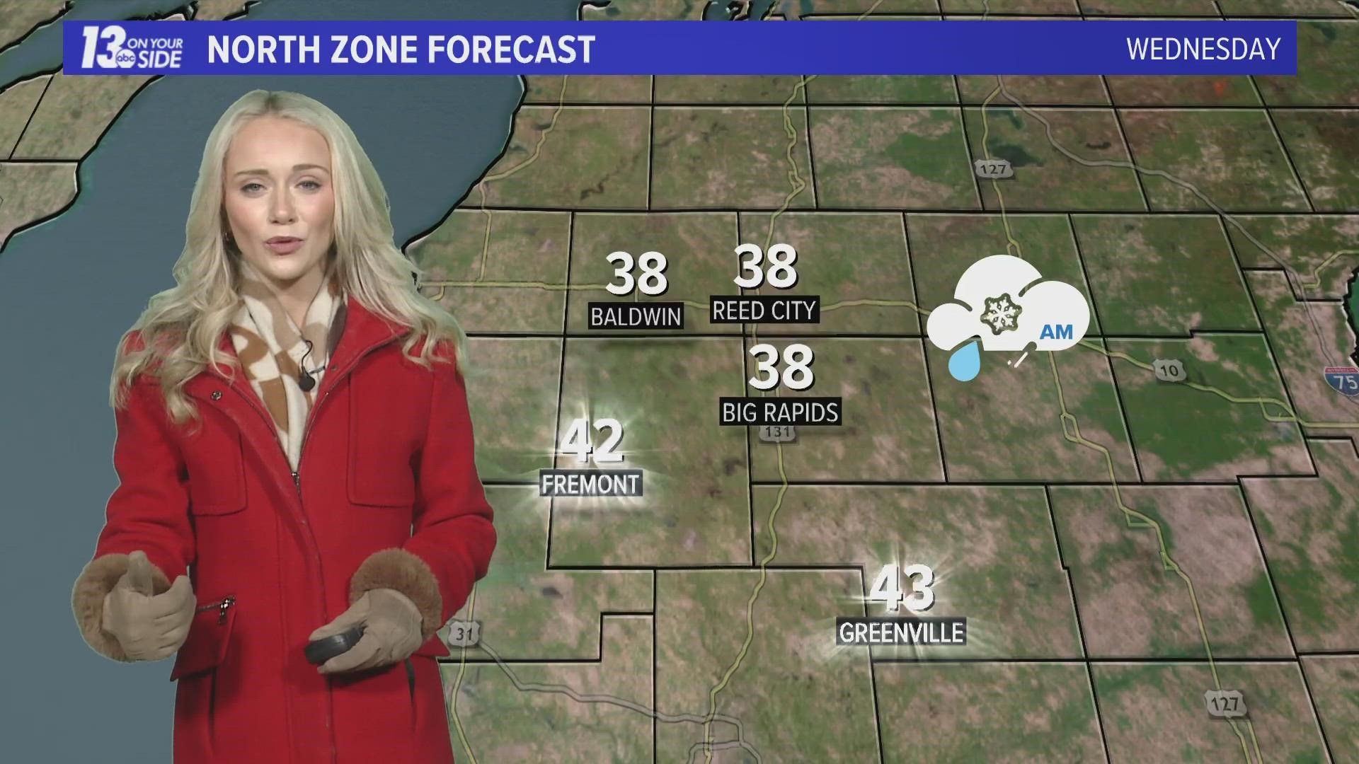
Our attention is now turned to another big system expected to bring high-impact snow and very strong winds.
►Make it easy to keep up to date with more stories like this. Download the 13 ON YOUR SIDE app now.
Have a news tip? Email news@13onyourside.com, visit our Facebook page or Twitter. Subscribe to our YouTube channel.