

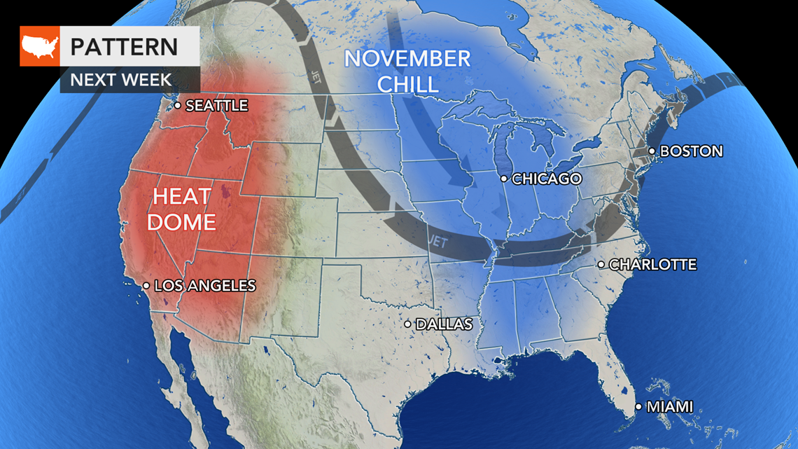
Autumn officially began on Sept. 22, but it certainly hasn't felt like it across the Midwest as unusually warm weather has been gripping the region this week. Forecasters say big changes are on the way, and the places like Minneapolis, Chicago and Detroit and many others may seemingly skip over the first part of fall and could be plunged into a November-like pattern next week.
The main culprit behind the dramatic weather changes will be the jet stream, which AccuWeather meteorologists expect to take a big southward dip over the central United States. That will send waves of chilly air more typical of November diving south from Canada. Some cooler air will eventually reach the Eastern Seaboard too, but it may be delayed and have much less punch when compared to blasts of crisp air headed straight for the Midwest.
A more typical pattern for the jet stream during late September and early October would be more of a straight line, or west-to-east flow, that keeps weak storms moving along at a fast pace and brief alternating surges of warmth and doses of cool air.

When the jet stream bulges more dramatically southward and northward like the setup predicted across the United States next week, cold air can advance well to the south in the lunges and surge well to the north in the bulges.
Thus, the clock is ticking on the latest surge of warmth over the Plains and Midwest that has brought widespread highs ranging from the middle 70s F to the middle 80s, averaging 5-10 degrees Fahrenheit above normal.
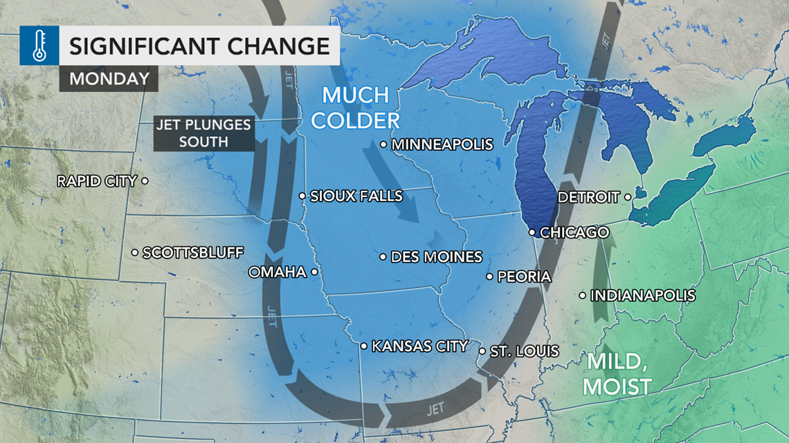
The leading edge of the first push of cooler air in a series will sweep from the northern Plains on Saturday to the central Plains and part of the Great Lakes region during Sunday and Monday.
Just ahead of the cooler air, a couple of weather systems can trigger locally gusty thunderstorms and perhaps a couple of isolated tornadoes over the Upper Peninsula of Michigan and northern Wisconsin during Friday afternoon and again Saturday afternoon.
"This first cool push will send temperatures plummeting from levels more typical of early September back to average or slightly below average for the end of September and the start of October," according to AccuWeather Meteorologist Jake Sojda.
Average highs range from the lower 60s over the northern tier of the Great Lakes to the middle 70s over the central Plains and Ohio Valley during late September.
The cooler air will sweep across Minneapolis from Saturday to Sunday then into Chicago from Sunday to Monday. By Sunday in Minneapolis and Monday in Chicago, temperatures will be no higher than the 60s.

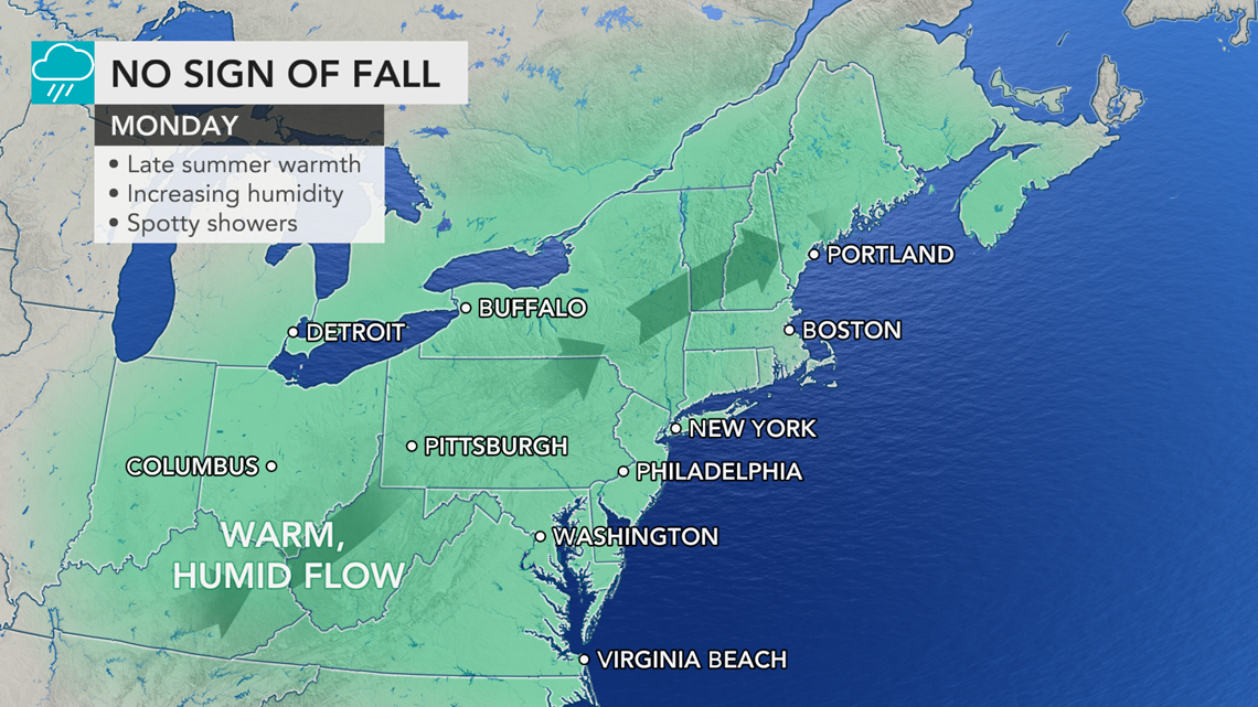
Farther to the east, the leading edge of the cooler air may take progressively longer to advance which is atypical of cool weather outbreaks in late September and October. Often these cool fronts may take only a couple of days to sweep from the northern Plains to the Northeast coast. However, this first advance could take almost a week before reaching the Atlantic shoreline.
"Where the coldest air sets up is highly dependent on where the axis of the dip in the jet stream develops," according to AccuWeather Senior Meteorologist Joe Lundberg.
"Since the jet stream dip will be centered over the Mississippi Valley and Great Lakes, rather than the Appalachians or the Eastern Seaboard, the cool air may have trouble at first reaching the Atlantic coast but less resistance in dipping well to the south over the Central states," Lundberg explained.
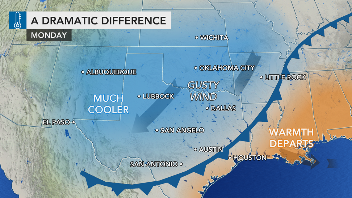
The cool air is scheduled to reach Dallas and Shreveport, Louisiana, on Monday, when highs are forecast to be in the lower 70s, but it may take until a second push of cooler air arrives and catches up with the first dose to get the cooler air to the East Coast days later.

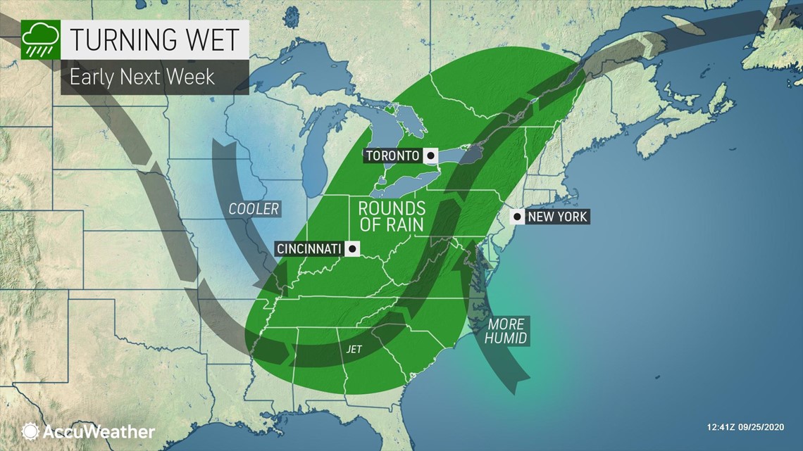
It is possible the big temperature drop may not occur in places such as Washington, D.C., Philadelphia, New York City and Boston until Thursday or Friday, depending on whether or not a storm forms along the leading edge of the cool air and causes a delay.
The storm could form along the Gulf Coast, but its development is not certain at this time.

"In addition to the amount of rain that such a storm might produce as it moves along from the Deep South to the Northeast states, there is the matter of the timing of that rain and then the delay in the cooldown the storm might cause along the Eastern Seaboard," Lundberg added.
In lieu of a major storm, a northward stream of moisture from the Gulf of Mexico and the Atlantic should be enough to bring at least a few showers as both fronts advance in the Midwest and then to the East.

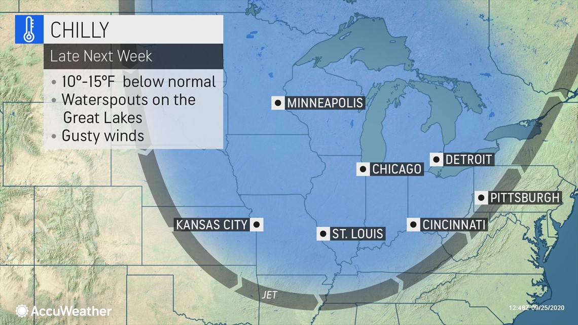
The second push of cool air that drops into the Midwest during the middle to latter part of next week will be the one to usher in the true November-like air. During this time, the sky and weather conditions will look and feel like a few weeks before Thanksgiving, rather than Halloween.
Daytime highs will be mainly in the 50s over the Midwest during the second half of next week. Factoring in a breeze and extensive cloud cover, AccuWeather RealFeel® Temperatures may be in the 40s and even the 30s in some cases.
The same pattern later next week, with its cold air aloft, will create a great deal of shower activity over the Midwest and can be enhanced by the warm waters of the Great Lakes. So much so, there is the potential for waterspouts over the Great Lakes, and some of the heavier showers that extend well inland can even contain soft hail, known as graupel, and perhaps wet snowflakes.

The same process expected to cause the wind and showers may work against widespread frosts and freezes over the Midwest, at least initially.
Since normal temperatures are trending downward at a quick pace this time of the year, record low temperatures are likely to be sparse during the outbreak. Temperatures may also stop well short of the low marks set during the frosty air that visited earlier in September when nights were clear and the air was dry and calm.
It may take until later during the first weekend of October or the start of the following week before skies clear and winds subside enough for frosty condition to develop from the central Plains to the Ohio Valley and parts of the East.
However, until the cool air arrives at your location, warm weather fans and outdoor enthusiasts may want to take in some last ditch summer activities before the pattern change sets it. The weather along the Atlantic coast into the first part of next week will offer up some great beach days with the tropics taking a breather.
The same high-amplitude pattern in the jet stream will allow heat to build in the West, which will again raise the risk level for erratic wildfire behavior in what has already be a deadly and devastating season.