GRAND RAPIDS, Mich. — Lake-effect snow bands have been impacting travel since the morning hours Thursday and will continue in waves throughout the evening and into tonight. While at times snowfall may take a break, and even a bit of sunshine may come through, these pauses will be short lived and snow should be expected at any time.
The Breakdown
Snow is continuing to intensify this afternoon into the evening. This is going to cause significant travel issues on the roadways for your evening commute. Just about everywhere is being impacted by this disorganized lake-effect snow, although it will organize into bands as we head into Friday.
This will limit snowfall totals for some and intensify them for others, leading to localized snowfall totals in the double digits.
Another round of lake-effect snow will fire up on Saturday. This will bring additional accumulation that is NOT included in the totals below. By Sunday the lake effect machine will shut down and a much quieter forecast will take shape.
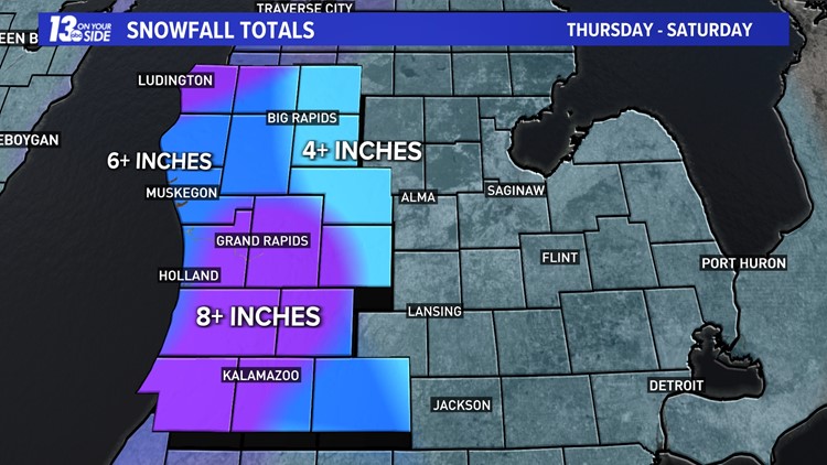
Snowfall Totals
Our forecast remains on track now through Saturday morning when it comes to snowfall totals.
Purple = 8+ inches
Dark Blue = 6+ inches
Light Blue = 4+ inches
This is the LOW end of the range. (+) indicates that there will likely be locally HIGHER amounts within each location. There will be spots in the purple shading that pick up over a foot of snow.
This is a lake-effect snow event, so conditions will vary largely over short distances. Also, this is a multi-day lake effect event so it won’t all fall at once but be prepared for times of difficult travel.


Impacts
This will be a prolonged and high-impact event, so make sure you are adjusting your travel plans with delays in mind. Reduced visibility is likely and roads will be congested.

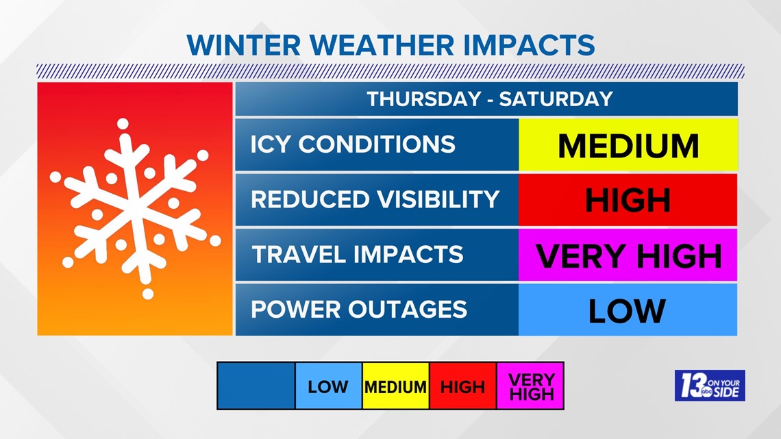
School closings are very likely. With high amounts of snow coming this evening, I even foresee some schools closing tonight rather than tomorrow morning. Roads are already congested and slow-moving and things have only just begun.


Keep with 13 ON YOUR SIDE through the storm for the latest forecast updates and school/event closings and delays. Track the snow with radar on the 13 ON YOUR SIDE News & Weather apps!
►Make it easy to keep up to date with more stories like this. Download the 13 ON YOUR SIDE app now.
Have a news tip? Email news@13onyourside.com, visit our Facebook page or Twitter. Subscribe to our YouTube channel.