GRAND RAPIDS, Mich. — It's nearly the unofficial start of summer and the forecast is starting to look like it! This week's outlook is very quiet and that will likely extend into the holiday weekend.
Our average afternoon high sits at 72° for Memorial Weekend and Friday through Monday all look at or above average. While there is still some flexibility in the exact numbers, I don't imagine any significant changes to the forecast between now and then.
Here's the current breakdown:
Friday
Sunny and mild. High 74°.
Friday Night
Mostly clear and cool. Low 48°.
Saturday
Mostly sunny and warmer. High 79°.
Saturday Night
Mostly clear and seasonable. Low 51°.
Sunday
Sunny and warm. High 85°.
Sunday Night
Partly cloudy and mild. Low 56°.
Memorial Day
Mostly sunny and warm. High 84°.
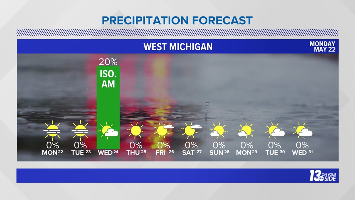
Where’s the rain? 2023 started off at a record pace – in terms of precipitation – but has come to a grinding halt throughout the month of May.
Everything is lining up for it to be Grand Rapids’ second driest May on record as a prolonged stretch of little to no rainfall continues through the end of the month. Since May 9, only 0.03” of rain has been recorded in Grand Rapids. This is the driest stretch of weather for the city since late November to early December of 2020.

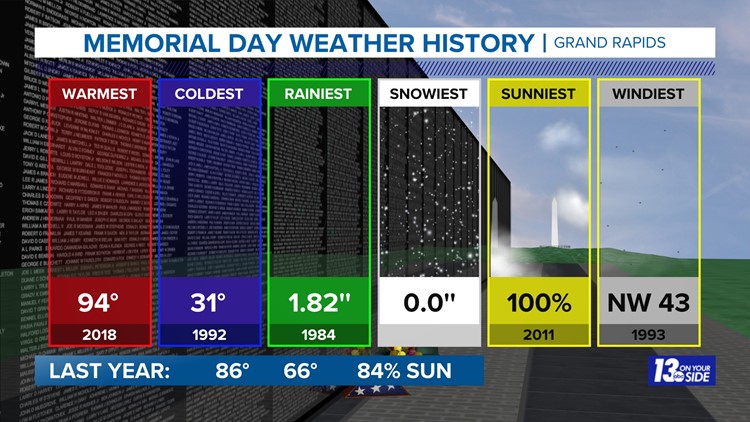
In terms of weather history, we have seen the good and the bad on this holiday weekend. Although, in recent years we have been trending warmer and warmer. Just last year Grand Rapids was in the mid-80s and our record warmest Memorial Day was just in 2018 at 94°. The coldest was back in 1992 at 31° - brr!


So, grab the swimsuits and enjoy the weekend! Just remember safe swimming practices and that the water in the big lakes is still too cold just to dive in.
We will likely make small changes to this forecast throughout the week, so be sure to continue to check in!
-Meteorologist Samantha Jacques
6-10 Day Outlook
Sat. May 27 through Wed. May 31 calls for above average temperatures and below average precipitation. Average highs are around 74-75° with an average precipitation of 0.62".
8-14 Day Outlook
Mon. May 29 through Sun. Jun. 4 calls for above average temperatures and near average precipitation. Average highs are around 74-76° with an average precipitation of 0.89"
Have a 30-second video or photo to share? We'd love to share it with everyone! Share your images by texting your name and location to 616.559.1310 or email to Weather@13OnYourSide.com or post it to our 13OnYourSide Facebook Page
►Make it easy to keep up to date with more stories like this. Download the 13 ON YOUR SIDE app now.
Have a news tip? Email news@13onyourside.com, visit our Facebook page or Twitter. Subscribe to our YouTube channel.