

GRAND RAPIDS, Mich. — The first system-snow since mid-January is poised to bring heavy, wet snow to West Michigan before sunrise Friday, impacting travel and events throughout the day. Some locations could see record daily snowfall amounts for March 22.
TIMELINE
The timeline hasn't changed in the past 24 hours: the snow will arrive before 4 a.m. Friday and quickly spread across the area affecting the morning commute with up to 1½" of snow. Likely, most of that snow will be melting, so the morning commute may just be slower than usual. However, by noon at least 3" will have fallen, affecting lunch-hour traffic with accumulation likely on the grassy areas. By late afternoon into the evening at least 6"+ will have fallen, likely affecting the evening rush hour. Plan accordingly!
IMPACTS
The impacts have largely remained unchanged since Tuesday, but I did up the travel impact to HIGH, due to the timing of the snowfall.
- High Winds - Low Impacts
- Reduced Visibility - Medium Impacts
- Travel - High Impacts
- Power Outages - Medium Impacts


SNOWFALL AMOUNTS
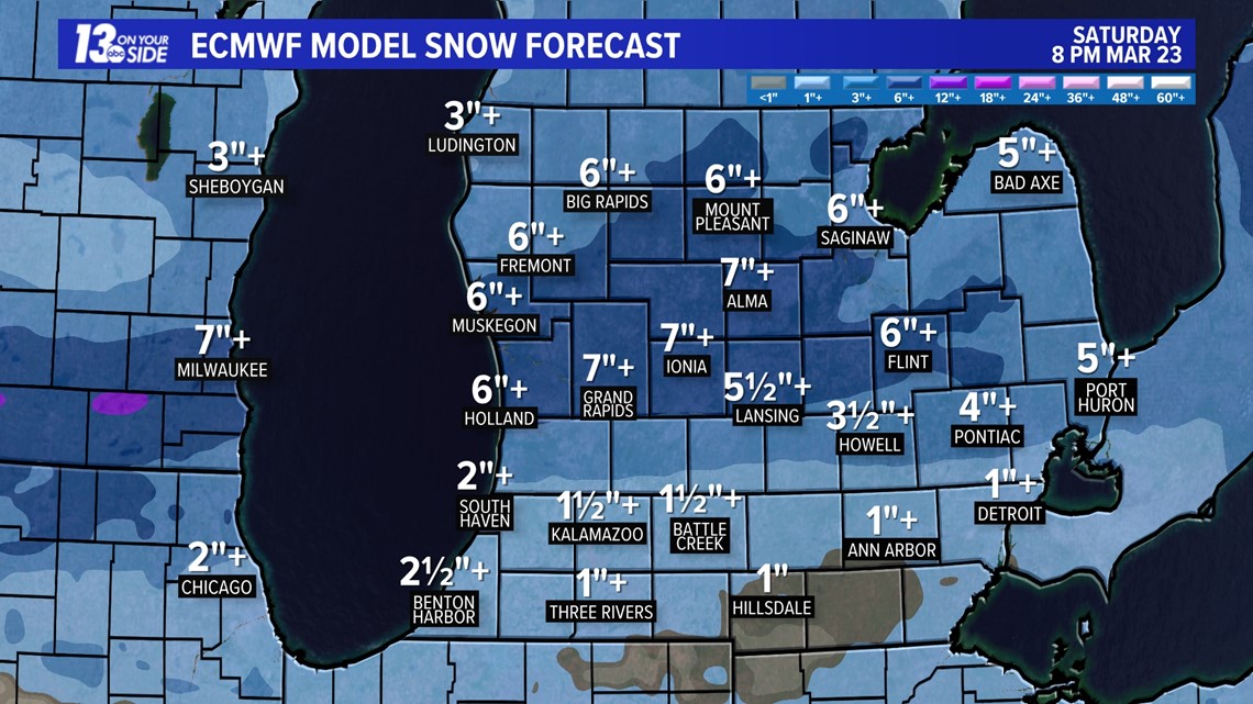
Once again, the Euro model snow forecast has changed very little, either with the amount of snow expected or the higher-impacted areas. Nonetheless, some variation is still possible prior to the arrival of the snow early Friday morning. Here is the amount of snow expected to fall; the amount of accumulation will be less.
- Grand Rapids, Ionia - 7+".
- Muskegon, Holland, Fremont, Big Rapids - 6+".
- Ludington - 3+".
- South Haven - 2½+".
- Kalamazoo, Battle Creek - 1½+".

RECORD SNOWFALL
Here are the record daily snowfall amounts and the year the records were set for March 22.
- Holland - 10.0'' in 1916.
- Muskegon - 7.0'' in 1932.
- Kalamazoo - 7.0'' in 1955.
- Battle Creek - 7.0'' in 1916.
- Grand Rapids - 6.3'' in 1965.
Be sure to get the latest updates throughout the week from the 13 On Your Side team of meteorologists.


Chief Meteorologist George Lessens
George is a graduate of Penn State University working for 13 On Your Side for over 43 years. He is a Certified Broadcast Meteorologist (CBM), a thirteen-time MAB® Weathercast Award Winner, two-time EMMY® Award Winner, NATAS® Silver Circle Award Winner, Weather-Ready Nation® Ambassador, and the AMS Charles Mitchell Award for lifetime service.
Contact me at: GeorgeLessens@13OnYourSide.com
Follow me on X/Twitter @glessens and Facebook GeorgeLessensWZZM
Have a 30-second video or photo to share? We'd love to share it with everyone! Share your images by texting your name and location to 616.559.1310 or email to Weather@13OnYourSide.com or post it to our 13OnYourSide Facebook Page