
GRAND RAPIDS, Mich. — Wednesday brought the official declaration of a Blizzard Warning for West Michigan. This is the first Blizzard Warning in West Michigan since 2019, and the first warning in Grand Rapids since the Groundhog Day Blizzard of 2011.
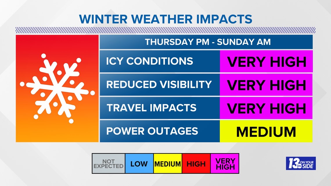
All of this is to say we are not dealing with the usual run of the mill winter storm here in West Michigan. We are expecting widespread heavy snowfall, winds that will gust over 50 mph and visibility that will be well below a mile for hours at a time.
Travel will be difficult, if not impossible, for periods of time starting Thursday evening and running through Saturday evening.

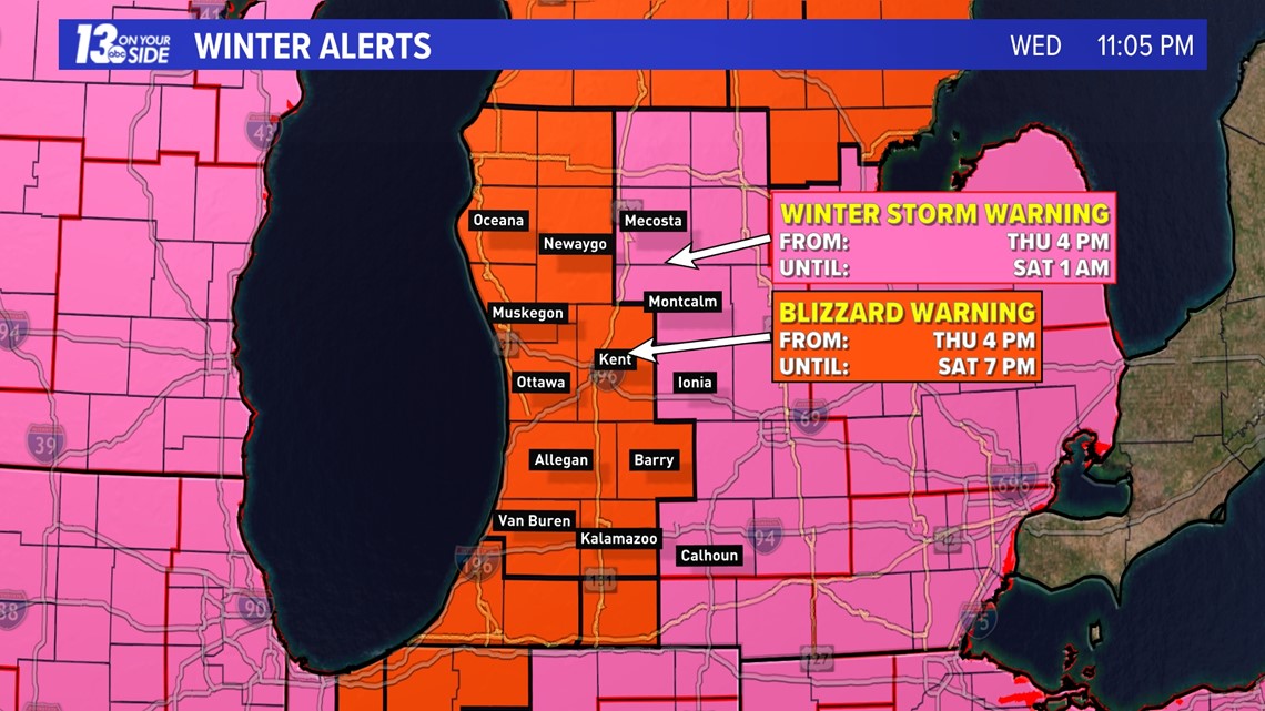
When it comes to a blizzard, it's not just snowfall that is the cause. You need winds at or frequently above 35 mph, visibility under a 1/4 mile, and for these conditions to last 3 hours or more.
This won't be an issue with our forecast and these criteria could be met for most of the day on Friday and into Saturday.

The timeline for this storm remains largely unchanged. Some wintry mix, but mostly snow, will start to fall on Thursday afternoon. Conditions will worsen overnight Thursday with blizzard conditions taking over on Friday.
Lake-effect snow continues Friday night and through most of Saturday, with the heaviest tapering off on Saturday evening. Some lingering lake-effect will make it into Christmas day, but not nearly as heavy or as windy.


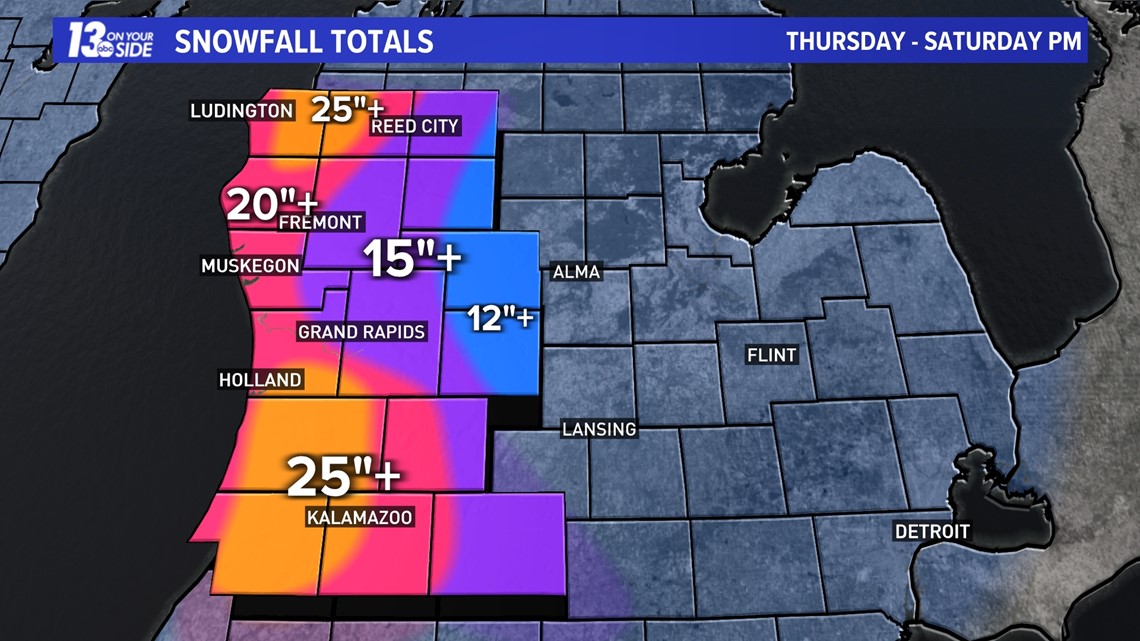
As we continue to get closer to those first flakes falling, we are getting a better handle on the expected snowfall, as well. Before the additional lake-effect falls on Saturday, most of West Michigan will likely see a foot or more of snowfall already on the ground.

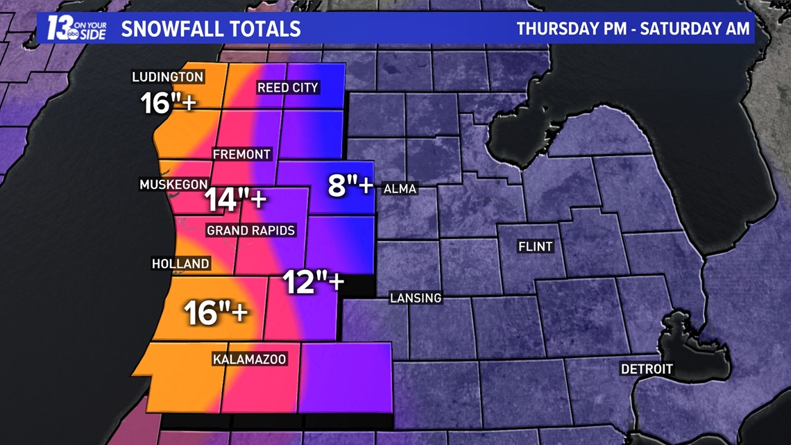
By the time the snow comes to an end on Saturday night, these totals will be pushing well over 2 feet in some of the hardest hit spots.

It's not just the snowfall on the way to West Michigan, but howling winds and falling temperatures as well. Highs will be in the teens this weekend, and wind chills will spend much of this time below zero.
This is a dangerous storm, so make sure you are staying safe, staying warm, and staying with 13 On Your Side for the latest details as they develop!
-- Meteorologist Michael Behrens
Follow me on social media! Facebook Meteorologist Michael Behrens, Twitter @MikeBehrensWX, and Instagram @MikeBehrensWX.
Email me at: MBehrens@13OnYourSide.com
Have a 30-second video or still photo to share? We'd love to share it with everyone! Email your image to Weather@13OnYourSide.com or post it to our 13OnYourSide Facebook Page.
►Make it easy to keep up to date with more stories like this. Download the 13 ON YOUR SIDE app now.
Have a news tip? Email news@13onyourside.com, visit our Facebook page or Twitter. Subscribe to our YouTube channel.