GRAND RAPIDS, Mich. — Wednesday into Thursday looks to bring a major winter storm, including snow, ice, freezing rain, and sleet. As of now, a lot of details still need to be ironed out, but areas to the north look to see accumulating snowfall, while southern portions of West Michigan will likely see significant ice.
We have had our fair share of snowfall this winter, but dealing with ice is a whole different battle.
What is an 'Ice Storm':
An ice storm describes damaging ice accumulations due to freezing rain and sleet. This often results in loss of power and extremely dangerous walking and driving conditions.
An Ice Storm Warning is issued by the National Weather Service when freezing rain produces significant and possibly damaging accumulations of ice. This typically means more than 1/4" of ice is expected to accumulate.
As of now, there are no watches or warnings issued but there will likely be some variations of either a Winter Storm Watch / Winter Storm Warning / or even an Ice Storm Warning issued in the coming days.
Impacts
We all know that just a thin coating of ice can create havoc on roadways, but heavier amounts can create a travel nightmare, widespread power outages, and even damage trees.
A glaze of ice will cause some low-end concerns, such as slick spots and difficult driving. We will likely exceed this amount of ice everywhere south of I-96.


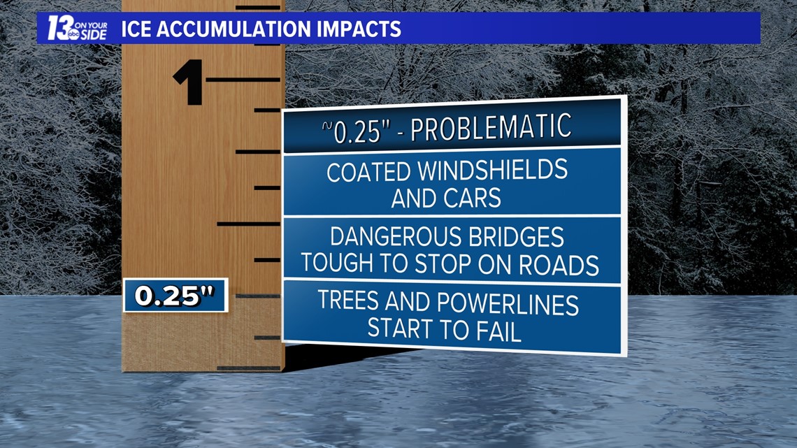
Anything near a quarter inch or more becomes problematic. This is when cars become coated in ice, it becomes very difficult to stop on roads and bridges, and power begins to fail. This outcome is looking increasingly likely for portions of West Michigan.

Ice becomes crippling anytime a half inch or more is reached. This could cause widespread power outages for numerous days, tree damage, and extremely dangerous travel. This is not out of the realm of possibilities, but we are still trying to nail down this portion of the forecast.


How to Prepare
Preparing for an ice storm can be difficult, but there are things you can do. Make plans to limit any time spent on roadways. With this system looking to impact Wednesday evening's commute and Thursday morning's commute, people should find alternative timeframes to travel or work from home if possible.
In the case that one loses power, be sure to charge all items, such as cell phones and laptops. Also, alternative sources of heat may be necessary. Things like fireplaces, generators, and portable space heaters will be handy. Although, you should always use caution. You should NEVER use portable generators indoors and they should be kept 20 feet away from your home to prevent carbon monoxide poisoning.
Freezing containers of water for ice can help keep things in the fridge and freezer colder for longer and even be used for drinking water if necessary. An unopened fridge can keep cold for approximately 4 hours and an unopened freezer can last up to 48 hours if full.
Finally, please continue to check in all week long as this forecast will be evolving and impacts are expected to be significant.
►Make it easy to keep up to date with more stories like this. Download the 13 ON YOUR SIDE app now.
Have a news tip? Email news@13onyourside.com, visit our Facebook page or Twitter. Subscribe to our YouTube channel.