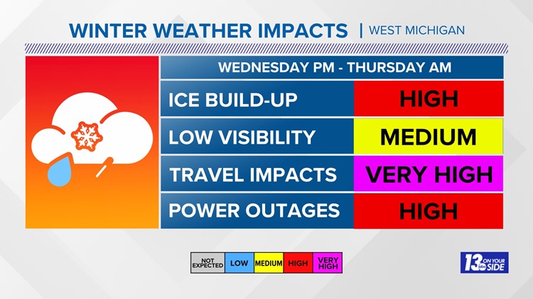
GRAND RAPIDS, Mich. — A major winter storm is expected for much of West Michigan Wednesday and Thursday with significant snow and ice likely to impact travel and activities.
Strong winds are also likely in the wake of this winter storm that could also lead to significant power outages.
Tracking and Timeline
This winter storm is unlike the pre-Christmas Blizzard in December of 2022, which was driven by a dynamic low pressure system ushering in arctic air, leading to immense lake-effect snow totals and impressive drifting with wind gusts to 40+ mph. That storm primarily affected four or five counties in West Michigan.
This time around, it is due to impressive amounts of Gulf of Mexico moisture racing north and slamming into a boundary of arctic air embedded over the Northern U.S. The precipitation will be snow on the northern edge of the precipitation with sleet dividing the snow from the freezing rain on the southern edge. This storm will affect nearly all of West Michigan.
The winter storm precipitation begins around mid-day Wednesday and intensifies quickly during the afternoon, leading to difficult travel for the Wednesday evening commute. The duration of the heaviest precipitation will be around 12-15 hours, tapering off in the early hours before sunrise Thursday.
Amounts and Impacts
Snowfall could reach impressive amounts of 6''+ (and locally higher amounts) generally north of I-96. This general location depends on exactly where the boundary sets up and for how long. It could vary by several miles. Less snow will fall along and south of I-96.

Icing from sleet and freezing rain could be hazardous with areas along and south of I-96 with ¼-½'' amounts upwards to 1¼'' along I-94.

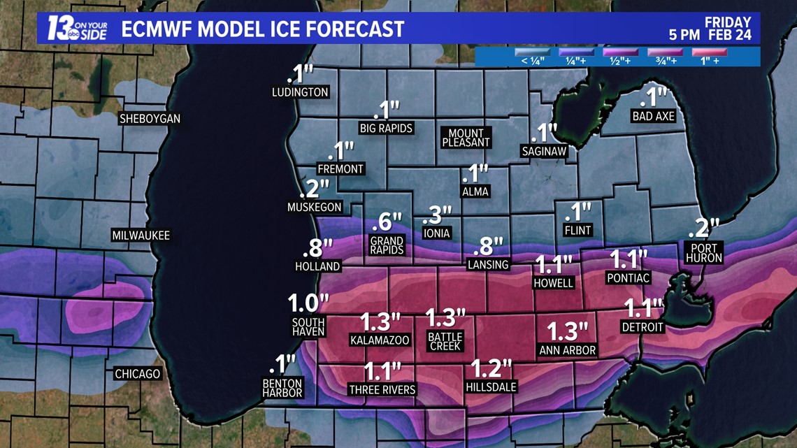
Keep in mind, these are estimates of precipitation totals and may not reflect the exact amounts any one location may get. What it does show is the potential for these amounts from this particular model run. Several weather model runs from over several days have consistently shown these amounts and locations.
The impacts to travel and activities are likely to be greatest from Wednesday afternoon through Thursday, with some recovery not taking place before Friday.


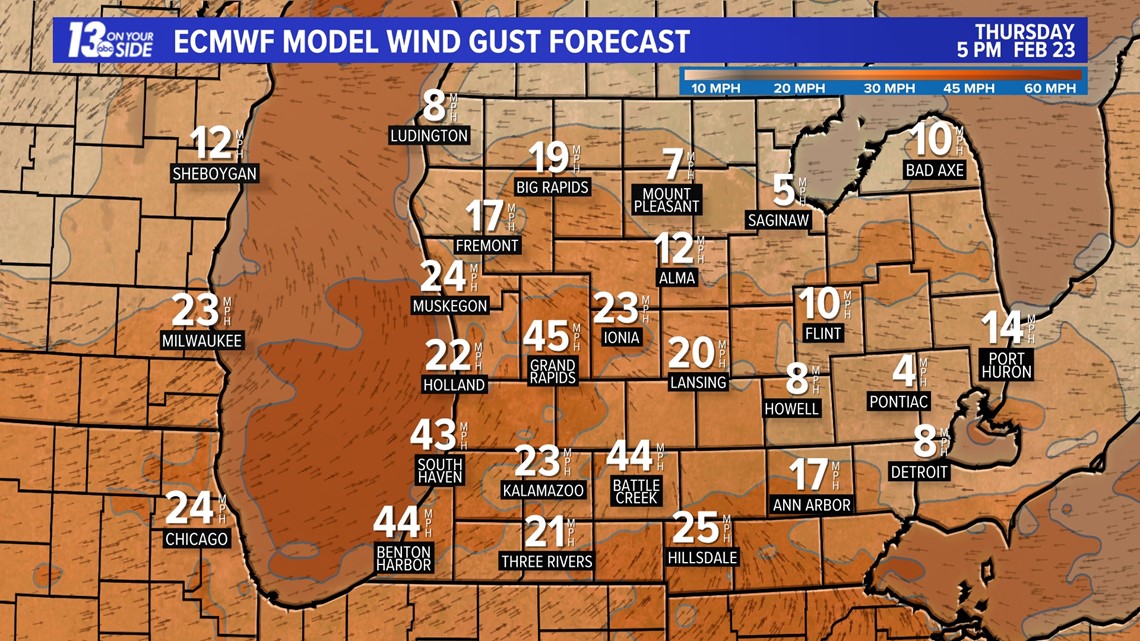
Strong Winds
Strong winds to 40+ mph could lead to power outages, especially where ice accumulates the heaviest on power lines and tree limbs.

Click here for the Consumer Energy Power Outage Map.
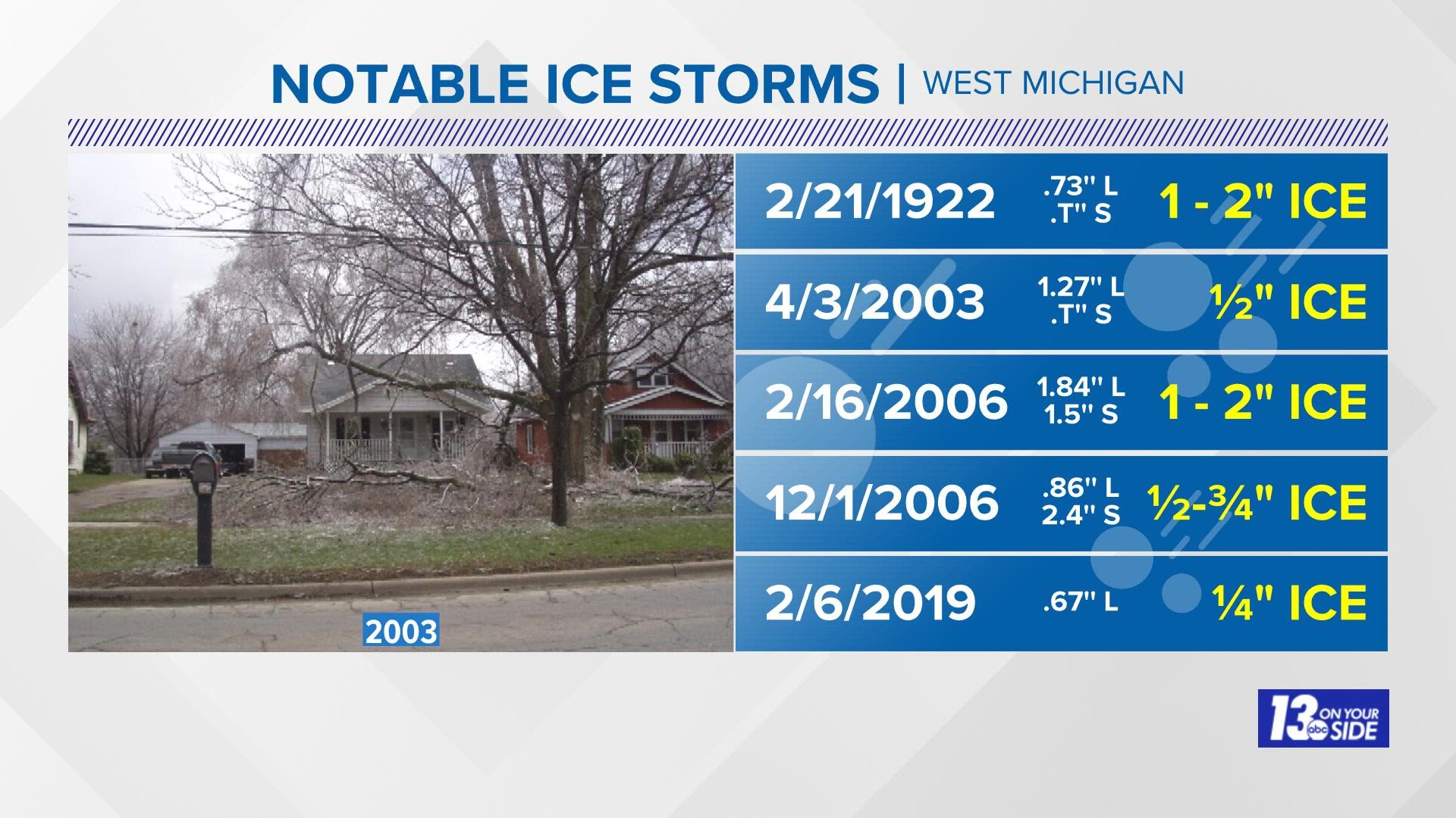
Notable Ice Storms
The most-recent notable ice storm occurred on Feb, 6, 2019 when 2/3rds of an inch of (L)iquid resulted in ¼'' of ice accumulation, a little thicker (and more slippery than) a banana peel.
More impactful events happened in April and in December of 2006. The April 3, 2003 ice storms occurred during Spring Break, leaving thousands without power while families vacationed down south.
Further Ahead
As the storm winds down, early Friday temperatures will range from the 20s north, to the 50s south, before plummeting into the 10s by early Saturday - resulting in a "flash freeze," meaning any precipitation that hasn't melted will be frozen in place until above-freezing temperatures slowly return over the weekend. This will lengthen the recovery time by hours, or even days.
Be safe out there and continue to watch the 13 ON YOUR SIDE Weather Team for updates.
Chief Meteorologist George Lessens
George is a graduate of Penn State University working for 13 ON YOUR SIDE for over 42 years. He is a Certified Broadcast Meteorologist (CBM), a twelve-time MAB® Weathercast Award Winner and two-time EMMY® Award Winner.
Contact me at: GeorgeLessens@13OnYourSide.com
Follow me on Twitter @glessens and Facebook GeorgeLessensWZZM
Have a 30-second video or photo to share? We'd love to share it with everyone! Share your images by texting your name and location to 616.559.1310 or email to Weather@13OnYourSide.com or post it to our 13OnYourSide Facebook Page