

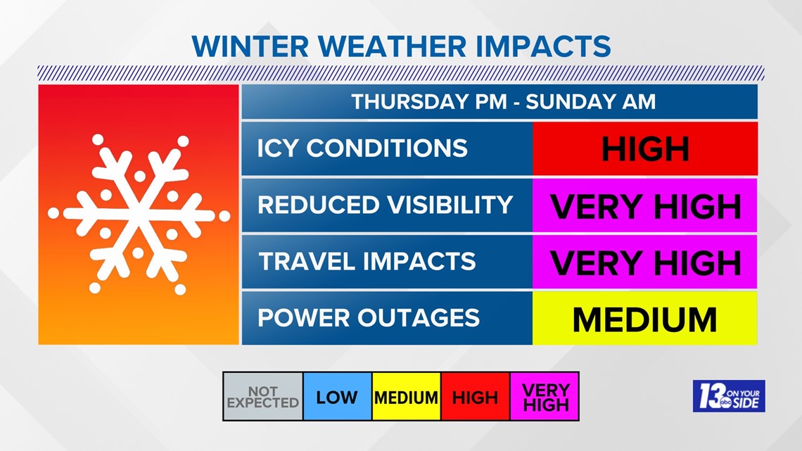
GRAND RAPIDS, Mich — The time is now to travel and get any last-minute errands done. After Thursday night, travel will be very difficult.
Heavy snow, intense winds, and a rush of arctic air are expected Thursday afternoon through Saturday night.
Let's start with a breakdown of the timing of this event.
Thursday Afternoon
The event will begin as a wintry mix around 4 pm. This mix looks to switch completely to snow Thursday evening, intensifying overnight Thursday into Friday morning. As of now, accumulations could be from 4 to 8 inches by 8 am Friday morning. This will cause quick deterioration of roadways and congested travel.
Friday
Friday is when things really get nasty. Heavy snow will fall and become intense in the afternoon hours. Not only will we have accumulating snowfall but winds will ramp up significantly. 50+ mph wind gusts are likely, causing blizzard-like conditions.
What does that mean?
- Sustained wind of 35mph or greater.
- Considerable falling and/or blowing snow reducing visibility to under a quarter mile.
- Conditions continue for at least three consecutive hours!
It's been three years since the National Weather Service has issued a Blizzard Warning and the chances of that are looking increasingly likely. As Meteorologist Blake Hansen mentioned in his tweet, regardless of the warning types, major impacts are expected. This will likely cause airline cancellations and delays.
Winds could also cause isolated to scattered power outages.
Saturday
The system will begin to exit the region on Saturday, but that does not mean an end to the snowfall. Rounds of lake effect snow are expected Saturday afternoon. NW lake-effect snow usually results in heavy accumulation in Ottawa, Kalamazoo, Allegan, Van Buren, Mason, and Lake County. While it's too early to determine how much more snow will accumulate, those areas should be prepared.
In addition to lake-effect snow, winds will still be ramped up, but slightly calmer than Friday. Regardless, blowing and drifting snow remains a concern. Plus, temperatures begin to tumble into the teens, which means feels like conditions are in the single digits, if not sub-zero, Saturday and Sunday.
All in all, this is a high-impact winter storm and the time to prepare is now. Travel will be extremely hazardous Friday and Saturday and plans should be tailored accordingly.

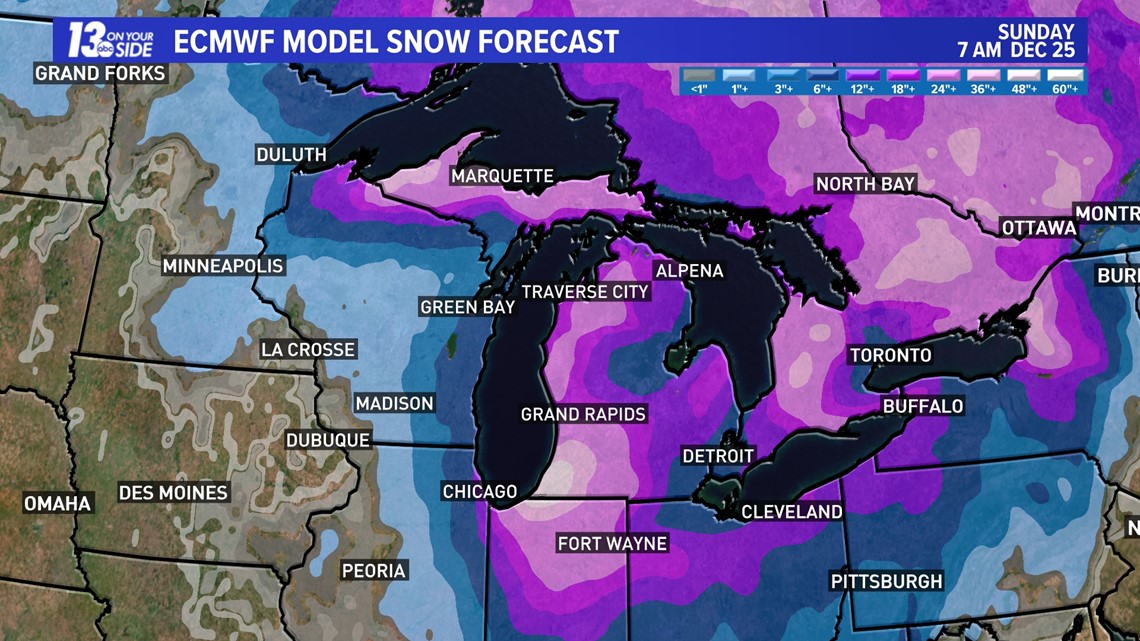
We will be releasing more detailed snowfall totals tomorrow morning, but here is a broad view of what we are expecting. Consistency between model runs is increasing our confidence and making it more and more clear that impacts will be great.

Have a 30-second video or photo to share? We'd love to share it with everyone! Share your images by texting your name and location to 616.559.1310 or email to Weather@13OnYourSide.com or post it to our 13OnYourSide Facebook Page