MICHIGAN, USA — Impactful winter weather has continued across West Michigan, with several inches of fresh snowfall on the ground and the arrival of bitterly cold temperatures. Unfortunately, conditions will only worsen as we continue into Friday evening with lake effect snow and gusty winds that increase in coverage and intensity.
As of Friday evening, a broad 4-8”+ of snow has fallen. Manageable for West Michigan standards, but road conditions have been poor with numerous accidents reported, as blowing snow becomes the main threat.
Lake effect snow will continue to remain steady throughout the rest of Friday and into Saturday. While the heaviest snowfall will remain closer to the lakeshore, strong winds out of the west-northwest will push lake effect well inland. It’ll take until Sunday for lake effect snow to diminish.
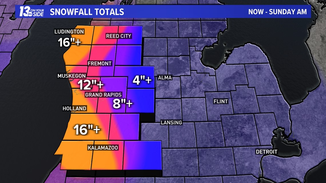
Additional, significant snow is still expected throughout Friday and into the weekend. Locations along US-131 to the lakeshore will pick up another 12-18” of additional snowfall by the end of the weekend. Snowfall totals will drop off considerably eastward of US-131, on the order of a few inches, but treacherous travel conditions will remain the same for all.


Numerous crashes, slide-offs and wrecks have been reported across West Michigan, with law enforcement urging motorists to stay off the roads unless absolutely necessary.

The lake effect snow will be made worse by the strong winds that develop throughout Friday. Gusts will increase to 40-50+ mph by the afternoon, which will cause widespread and severe blowing and drifting snow. Visibility will be greatly affected as well, with whiteout conditions expected throughout much of the region. All roads will be impacted, but north-south oriented roads will be the worse due to the west-northwest wind direction.


Travel conditions will remain treacherous throughout all of Friday, but the afternoon and evening hours will be the toughest. Travel is not recommended unless it’s a dire emergency. If you do plan to travel, make sure to have an emergency kit in your vehicle.


On top of the snow and wind, frigid arctic air has made inroads to the Great Lakes. Even with some moderation of the warmer waters of the Great Lakes, temperatures will struggle to climb out of the single digits throughout Friday and only settle into the 10s over the weekend. Salt is nearly ineffective with these temperatures, furthering treacherous travel conditions.
Factoring in the wind, “feels-like” temperatures will be anywhere between 0° and -20° throughout Friday and into the weekend. Frostbite can occur within 30 minutes on exposed skin with this magnitude of cold air.


In short, dangerous winter conditions will continue across West Michigan, with the worse conditions Friday afternoon through early Saturday morning. Stay with 13 ON YOUR SIDE throughout this blizzard for the latest information.
--The 13 On Your Side Weather Team
►Make it easy to keep up to date with more stories like this. Download the 13 ON YOUR SIDE app now.
Have a news tip? Email news@13onyourside.com, visit our Facebook page or Twitter. Subscribe to our YouTube channel.